
Faire un don
Équipez-vous pour votre prochaine aventure :
En tant que Partenaire Amazon, ce site perçoit une commission sur les achats éligibles sans surcoût pour vous.
Carte topographique Corbett Tiger Reserve
Cliquez sur la carte pour afficher l’altitude.
Faire un don
Équipez-vous pour votre prochaine aventure :
En tant que Partenaire Amazon, ce site perçoit une commission sur les achats éligibles sans surcoût pour vous.
À propos de cette carte
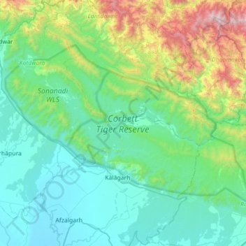
Nom : Carte topographique Corbett Tiger Reserve, altitude, relief.
Altitude moyenne : 632 m
Altitude minimum : 221 m
Altitude maximum : 2.488 m
Faire un don
Équipez-vous pour votre prochaine aventure :
En tant que Partenaire Amazon, ce site perçoit une commission sur les achats éligibles sans surcoût pour vous.
Autres cartes topographiques
Cliquez sur une carte pour visualiser sa topographie, son altitude et son relief.
Kotdwar
India > Uttarakhand > Kotdwara
Kotdwar lies on the western margin of the Himalayas, at an altitude of 454 m (1,490 ft) above sea level.
Altitude moyenne : 471 m
Faire un don
Équipez-vous pour votre prochaine aventure :
En tant que Partenaire Amazon, ce site perçoit une commission sur les achats éligibles sans surcoût pour vous.
Faire un don
Équipez-vous pour votre prochaine aventure :
En tant que Partenaire Amazon, ce site perçoit une commission sur les achats éligibles sans surcoût pour vous.
Kotdwar
India > Uttarakhand > Kotdwara
Kotdwar lies on the western margin of the Himalayas, at an altitude of 454 m (1,490 ft) above sea level.
Altitude moyenne : 471 m
Kotdwar
India > Uttarakhand > Kotdwara
Kotdwar lies on the western margin of the Himalayas, at an altitude of 454 m (1,490 ft) above sea level.
Altitude moyenne : 641 m
Kotdwar
India > Uttarakhand > Kotdwara
Kotdwar lies on the western margin of the Himalayas, at an altitude of 454 m (1,490 ft) above sea level.
Altitude moyenne : 471 m
Faire un don
Équipez-vous pour votre prochaine aventure :
En tant que Partenaire Amazon, ce site perçoit une commission sur les achats éligibles sans surcoût pour vous.
Faire un don
Équipez-vous pour votre prochaine aventure :
En tant que Partenaire Amazon, ce site perçoit une commission sur les achats éligibles sans surcoût pour vous.