
Faire un don
Équipez-vous pour votre prochaine aventure :
En tant que Partenaire Amazon, ce site perçoit une commission sur les achats éligibles sans surcoût pour vous.
Carte topographique Orland
Cliquez sur la carte pour afficher l’altitude.
Faire un don
Équipez-vous pour votre prochaine aventure :
En tant que Partenaire Amazon, ce site perçoit une commission sur les achats éligibles sans surcoût pour vous.
Orland
Orland is a city in Glenn County, California. The population was 7,291 at the 2010 census, up from 6,281 at the 2000 census, making Orland the most populous and fastest growing city in Glenn County. Orland is located 16 miles (26 km) north of Willows, at an elevation of 259 feet (79 m). Interstate 5, (north–south) passes west of the downtown area while State Route 32 (east–west) passes through downtown.
Faire un don
Équipez-vous pour votre prochaine aventure :
En tant que Partenaire Amazon, ce site perçoit une commission sur les achats éligibles sans surcoût pour vous.
À propos de cette carte
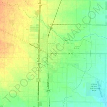
Nom : Carte topographique Orland, altitude, relief.
Altitude moyenne : 78 m
Altitude minimum : 62 m
Altitude maximum : 94 m
Faire un don
Équipez-vous pour votre prochaine aventure :
En tant que Partenaire Amazon, ce site perçoit une commission sur les achats éligibles sans surcoût pour vous.