
Faire un don
Équipez-vous pour votre prochaine aventure :
En tant que Partenaire Amazon, ce site perçoit une commission sur les achats éligibles sans surcoût pour vous.
Carte topographique Memel
Cliquez sur la carte pour afficher l’altitude.
Faire un don
Équipez-vous pour votre prochaine aventure :
En tant que Partenaire Amazon, ce site perçoit une commission sur les achats éligibles sans surcoût pour vous.
Memel
Memel-Zamani lies in the west-facing lee of the Drakensberg escarpment, the escarpment functioning as the continental divide. Its high elevation and close proximity to the escarpment are the major reason for Memel's cold winters. Visitors are frequently surprised by just how cold winter can be in Memel. Added to this is the fact that the town sits in a depression in the land, this depression being surrounded by distant mountains. Memel-Zamani lies near to the Klip River from where the towns water supply is drawn.
Faire un don
Équipez-vous pour votre prochaine aventure :
En tant que Partenaire Amazon, ce site perçoit une commission sur les achats éligibles sans surcoût pour vous.
À propos de cette carte
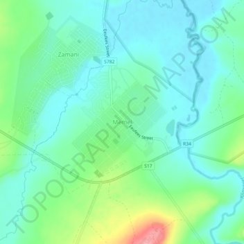
Nom : Carte topographique Memel, altitude, relief.
Altitude moyenne : 1.723 m
Altitude minimum : 1.697 m
Altitude maximum : 1.800 m
Faire un don
Équipez-vous pour votre prochaine aventure :
En tant que Partenaire Amazon, ce site perçoit une commission sur les achats éligibles sans surcoût pour vous.