
Carte topographique Saint-Jean-de-Cherbourg
Carte interactive
Cliquez sur la carte pour afficher l’altitude.
À propos de cette carte
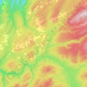
Nom : Carte topographique Saint-Jean-de-Cherbourg, altitude, relief.
Altitude moyenne : 333 m
Altitude minimum : 87 m
Altitude maximum : 586 m
Autres cartes topographiques
Cliquez sur une carte pour visualiser sa topographie, son altitude et son relief.
Matane
Canada > Québec > La Matanie
Matane, La Matanie, Bas-Saint-Laurent, Québec, Canada
Altitude moyenne : 108 m
Sainte-Félicité
Canada > Québec > La Matanie
Sainte-Félicité, La Matanie, Bas-Saint-Laurent, Québec, G0J 2K0, Canada
Altitude moyenne : 116 m
Lac au Sable
Canada > Québec > La Matanie > Les Méchins
Lac au Sable, Les Méchins, La Matanie, Bas-Saint-Laurent, Québec, Canada
Altitude moyenne : 395 m
Lac Paul
Canada > Québec > La Matanie > Rivière-Bonjour
Lac Paul, Rivière-Bonjour, La Matanie, Bas-Saint-Laurent, Québec, Canada
Altitude moyenne : 578 m
Ruisseau-Gagnon
Canada > Québec > La Matanie > Saint-René-de-Matane
Ruisseau-Gagnon, Saint-René-de-Matane, La Matanie, Bas-Saint-Laurent, Québec, Canada
Altitude moyenne : 153 m
Rivière-Bonjour
Canada > Québec > La Matanie
Rivière-Bonjour, La Matanie, Bas-Saint-Laurent, Québec, Canada, Mont Desjardins
Altitude moyenne : 741 m
Saint-René-de-Matane
Canada > Québec > La Matanie
Saint-René-de-Matane, La Matanie, Bas-Saint-Laurent, Québec, Canada
Altitude moyenne : 155 m
Mont Pointu
Canada > Québec > La Matanie > Rivière-Bonjour
Mont Pointu, Rivière-Bonjour, La Matanie, Bas-Saint-Laurent, Québec, Canada
Altitude moyenne : 649 m
Sainte-Paule
Canada > Québec > La Matanie
Sainte-Paule, La Matanie, Bas-Saint-Laurent, Québec, Canada
Altitude moyenne : 235 m
Les Méchins
Canada > Québec > La Matanie
Les Méchins, La Matanie, Bas-Saint-Laurent, Québec, G0J 1T0, Canada
Altitude moyenne : 265 m
Mont du Nid-d'Aigle
Canada > Québec > La Matanie > Rivière-Bonjour
Mont du Nid-d'Aigle, Rivière-Bonjour, La Matanie, Bas-Saint-Laurent, Québec, Canada
Altitude moyenne : 498 m
Saint-Thomas-de-Cherbourg
Canada > Québec > La Matanie > Les Méchins
Saint-Thomas-de-Cherbourg, Les Méchins, La Matanie, Bas-Saint-Laurent, Québec, Canada
Altitude moyenne : 448 m
Ruisseau-à-Sem
Canada > Québec > La Matanie > Les Méchins > Ruisseau-à-Sem
Ruisseau-à-Sem, Les Méchins, La Matanie, Bas-Saint-Laurent, Québec, Canada
Altitude moyenne : 85 m
Matane
Canada > Québec > La Matanie > Matane
Matane, La Matanie, Bas-Saint-Laurent, Québec, G4W 3B6, Canada
Altitude moyenne : 84 m
Saint-Adelme
Canada > Québec > La Matanie > Saint-Adelme
Saint-Adelme, La Matanie, Bas-Saint-Laurent, Québec, Canada
Altitude moyenne : 237 m
Lac Rouleau
Canada > Québec > La Matanie > Les Méchins
Lac Rouleau, Les Méchins, La Matanie, Bas-Saint-Laurent, Québec, Canada
Altitude moyenne : 385 m
Le Renversé
Canada > Québec > La Matanie > Saint-René-de-Matane > Le Renversé
Le Renversé, Saint-René-de-Matane, La Matanie, Bas-Saint-Laurent, Québec, G0J 3E0, Canada
Altitude moyenne : 270 m
Saint-René-de-Matane
Canada > Québec > La Matanie
Saint-René-de-Matane, La Matanie, Bas-Saint-Laurent, Québec, G0J 3E0, Canada
Altitude moyenne : 234 m
Saint-Léandre
Canada > Québec > La Matanie
Saint-Léandre, La Matanie, Bas-Saint-Laurent, Québec, Canada
Altitude moyenne : 190 m
Baie-des-Sables
Canada > Québec > La Matanie
Baie-des-Sables, La Matanie, Bas-Saint-Laurent, Québec, G0J 1C0, Canada
Altitude moyenne : 70 m
Grosses-Roches
Canada > Québec > La Matanie
Grosses-Roches, La Matanie, Bas-Saint-Laurent, Québec, G0J 1K0, Canada
Altitude moyenne : 164 m
Saint-Ulric
Canada > Québec > La Matanie
Saint-Ulric, La Matanie, Bas-Saint-Laurent, Québec, Canada
Altitude moyenne : 100 m