
Faire un don
Équipez-vous pour votre prochaine aventure :
En tant que Partenaire Amazon, ce site perçoit une commission sur les achats éligibles sans surcoût pour vous.
Carte topographique Prospect
Cliquez sur la carte pour afficher l’altitude.
Faire un don
Équipez-vous pour votre prochaine aventure :
En tant que Partenaire Amazon, ce site perçoit une commission sur les achats éligibles sans surcoût pour vous.
Prospect
According to the Köppen classification, Prospect is Dfb, or a humid continental climate. The town has warm and humid summers with cold winters. Precipitation is spread throughout the year, with thunderstorms frequent during the summer months, and heavy snowfalls during the winter months. Due to Prospect's elevation and location, temperatures are often colder, leading to snow in the town while lower towns to its east have rain. Like Connecticut, Prospect frequently experiences Nor'easters and Blizzards during the winter, which can bring heavy snowfall to the town.
Faire un don
Équipez-vous pour votre prochaine aventure :
En tant que Partenaire Amazon, ce site perçoit une commission sur les achats éligibles sans surcoût pour vous.
À propos de cette carte
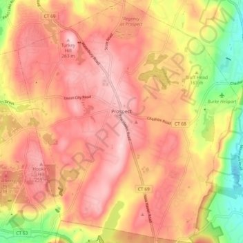
Nom : Carte topographique Prospect, altitude, relief.
Altitude moyenne : 193 m
Altitude minimum : 44 m
Altitude maximum : 279 m
Faire un don
Équipez-vous pour votre prochaine aventure :
En tant que Partenaire Amazon, ce site perçoit une commission sur les achats éligibles sans surcoût pour vous.
Autres cartes topographiques
Cliquez sur une carte pour visualiser sa topographie, son altitude et son relief.
Huntington
United States > Connecticut > Naugatuck Valley Planning Region > Shelton
Altitude moyenne : 111 m
Minortown
United States > Connecticut > Naugatuck Valley Planning Region > Woodbury
Altitude moyenne : 169 m
White Hills
United States > Connecticut > Naugatuck Valley Planning Region > Shelton
Altitude moyenne : 124 m
Faire un don
Équipez-vous pour votre prochaine aventure :
En tant que Partenaire Amazon, ce site perçoit une commission sur les achats éligibles sans surcoût pour vous.
Mad River
United States > Connecticut > Naugatuck Valley Planning Region > Waterbury > Fair Lawn
Altitude moyenne : 134 m
Fox Hollow
United States > Connecticut > Naugatuck Valley Planning Region > Cheshire
Altitude moyenne : 64 m
Westview Heights
United States > Connecticut > Naugatuck Valley Planning Region > Middlebury
Altitude moyenne : 159 m
Union City
United States > Connecticut > Naugatuck Valley Planning Region > Naugatuck
Altitude moyenne : 124 m
Faire un don
Équipez-vous pour votre prochaine aventure :
En tant que Partenaire Amazon, ce site perçoit une commission sur les achats éligibles sans surcoût pour vous.
Warsaw Park
United States > Connecticut > Naugatuck Valley Planning Region > Ansonia
Altitude moyenne : 107 m
Bunker Hill
United States > Connecticut > Naugatuck Valley Planning Region > Waterbury
Altitude moyenne : 140 m
Cedar Land
United States > Connecticut > Naugatuck Valley Planning Region > Southbury
Altitude moyenne : 103 m
Town Plot Hill
United States > Connecticut > Naugatuck Valley Planning Region > Waterbury
Altitude moyenne : 127 m
Faire un don
Équipez-vous pour votre prochaine aventure :
En tant que Partenaire Amazon, ce site perçoit une commission sur les achats éligibles sans surcoût pour vous.
Millville
United States > Connecticut > Naugatuck Valley Planning Region > Naugatuck
Altitude moyenne : 132 m
Bunker Hill
United States > Connecticut > Naugatuck Valley Planning Region > Waterbury
Altitude moyenne : 140 m
Bunker Hill
United States > Connecticut > Naugatuck Valley Planning Region > Waterbury
Altitude moyenne : 140 m
Traditions
United States > Connecticut > Naugatuck Valley Planning Region > Southbury > South Britain
Altitude moyenne : 112 m
Faire un don
Équipez-vous pour votre prochaine aventure :
En tant que Partenaire Amazon, ce site perçoit une commission sur les achats éligibles sans surcoût pour vous.
Minortown
United States > Connecticut > Naugatuck Valley Planning Region > Woodbury
Altitude moyenne : 169 m
Gulls Hollow
United States > Connecticut > Naugatuck Valley Planning Region > Bethlehem
Altitude moyenne : 243 m
Allentown
United States > Connecticut > Naugatuck Valley Planning Region > Plymouth
Altitude moyenne : 244 m
Faire un don
Équipez-vous pour votre prochaine aventure :
En tant que Partenaire Amazon, ce site perçoit une commission sur les achats éligibles sans surcoût pour vous.