
Faire un don
Équipez-vous pour votre prochaine aventure :
En tant que Partenaire Amazon, ce site perçoit une commission sur les achats éligibles sans surcoût pour vous.
Carte topographique Wao
Cliquez sur la carte pour afficher l’altitude.
Faire un don
Équipez-vous pour votre prochaine aventure :
En tant que Partenaire Amazon, ce site perçoit une commission sur les achats éligibles sans surcoût pour vous.
Wao
There are three possible etymology for the name of the municipality Wao. One is a local folklore which involved Bai Sa Raya, a Moro princess from a monarchy in Cotawato visited the area which is now known as "Wao" coincidentally during a serious drought. This led to the place to being called Wao from the word kawaw or uhaw in the local language which roughly translates to "I am thirsty". Another theory is that the place was named after a former creek in Eastern Wao which was extant prior to the arrival of Christian settlers in the 1950s. A third theory is that the name of the town was derived from the Maranao word liawao which means "high place", this is a reference to a Moro settlement existing in the current-day poblacion during the pre-1950 settlement era. Other nearby settlements are situated at a lower elevation that Liawao.
Faire un don
Équipez-vous pour votre prochaine aventure :
En tant que Partenaire Amazon, ce site perçoit une commission sur les achats éligibles sans surcoût pour vous.
À propos de cette carte
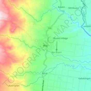
Nom : Carte topographique Wao, altitude, relief.
Lieu : Wao, Lanao del Sur, Bangsamoro, 9716, Philippines (7.59822 124.68416 7.67822 124.76416)
Altitude moyenne : 597 m
Altitude minimum : 369 m
Altitude maximum : 1.053 m
Faire un don
Équipez-vous pour votre prochaine aventure :
En tant que Partenaire Amazon, ce site perçoit une commission sur les achats éligibles sans surcoût pour vous.
Autres cartes topographiques
Cliquez sur une carte pour visualiser sa topographie, son altitude et son relief.