
Carte topographique Bukit Batok Nature Park
Carte interactive
Cliquez sur la carte pour afficher l’altitude.
À propos de cette carte
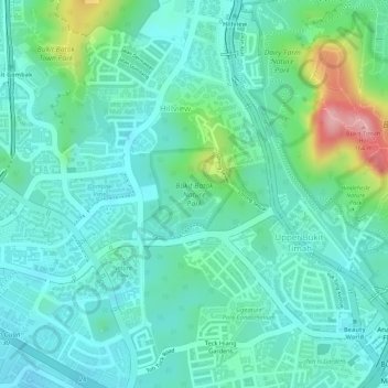
Nom : Carte topographique Bukit Batok Nature Park, altitude, relief.
Altitude moyenne : 45 m
Altitude minimum : 5 m
Altitude maximum : 168 m
The peak of Bukit Batok Hill stands at an elevation of 107m above sea level. Temperature ranges from 23°C to 30°C during "Winter/Wet" season. During Summer, temperature ranges from 24°C to 33°C.
Autres cartes topographiques
Cliquez sur une carte pour visualiser sa topographie, son altitude et son relief.