
Faire un don
Équipez-vous pour votre prochaine aventure :
En tant que Partenaire Amazon, ce site perçoit une commission sur les achats éligibles sans surcoût pour vous.
Carte topographique Wimauma
Cliquez sur la carte pour afficher l’altitude.
Faire un don
Équipez-vous pour votre prochaine aventure :
En tant que Partenaire Amazon, ce site perçoit une commission sur les achats éligibles sans surcoût pour vous.
À propos de cette carte
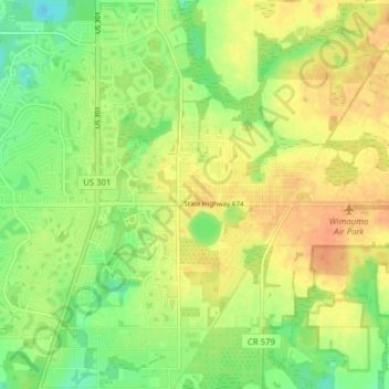
Nom : Carte topographique Wimauma, altitude, relief.
Lieu : Wimauma, Hillsborough County, Florida, United States (27.67959 -82.34689 27.74862 -82.28934)
Altitude moyenne : 23 m
Altitude minimum : 4 m
Altitude maximum : 39 m
Faire un don
Équipez-vous pour votre prochaine aventure :
En tant que Partenaire Amazon, ce site perçoit une commission sur les achats éligibles sans surcoût pour vous.
Autres cartes topographiques
Cliquez sur une carte pour visualiser sa topographie, son altitude et son relief.
Tampa
United States > Florida > Hillsborough County
Tampa is characterized by a predominantly flat topography, with an average elevation around 16 to 49 feet (5 to 15 meters) above sea level. The terrain is marked by low-lying areas and gentle slopes, with the highest points in the vicinity reaching approximately 62 feet (19 meters). This landscape is…
Altitude moyenne : 11 m
Faire un don
Équipez-vous pour votre prochaine aventure :
En tant que Partenaire Amazon, ce site perçoit une commission sur les achats éligibles sans surcoût pour vous.
Faire un don
Équipez-vous pour votre prochaine aventure :
En tant que Partenaire Amazon, ce site perçoit une commission sur les achats éligibles sans surcoût pour vous.
Faire un don
Équipez-vous pour votre prochaine aventure :
En tant que Partenaire Amazon, ce site perçoit une commission sur les achats éligibles sans surcoût pour vous.
Faire un don
Équipez-vous pour votre prochaine aventure :
En tant que Partenaire Amazon, ce site perçoit une commission sur les achats éligibles sans surcoût pour vous.
Arbors at Freedom Plaza
United States > Florida > Hillsborough County > Sun City Center
Altitude moyenne : 15 m
Faire un don
Équipez-vous pour votre prochaine aventure :
En tant que Partenaire Amazon, ce site perçoit une commission sur les achats éligibles sans surcoût pour vous.
Apollo Beach
United States > Florida > Hillsborough County > Apollo Beach
The history of Apollo Beach started in 1923 on land owned by the Dickman family, then used annually for farming and grazing pasture. Much of the land was mangrove and low-elevation and was considered uninhabitable.
Altitude moyenne : 6 m
Faire un don
Équipez-vous pour votre prochaine aventure :
En tant que Partenaire Amazon, ce site perçoit une commission sur les achats éligibles sans surcoût pour vous.
Faire un don
Équipez-vous pour votre prochaine aventure :
En tant que Partenaire Amazon, ce site perçoit une commission sur les achats éligibles sans surcoût pour vous.
Faire un don
Équipez-vous pour votre prochaine aventure :
En tant que Partenaire Amazon, ce site perçoit une commission sur les achats éligibles sans surcoût pour vous.
The Reserve of Old Tampa Bay
United States > Florida > Hillsborough County > Town 'n' Country
Altitude moyenne : 3 m
Faire un don
Équipez-vous pour votre prochaine aventure :
En tant que Partenaire Amazon, ce site perçoit une commission sur les achats éligibles sans surcoût pour vous.
Faire un don
Équipez-vous pour votre prochaine aventure :
En tant que Partenaire Amazon, ce site perçoit une commission sur les achats éligibles sans surcoût pour vous.
Hillsborough Heights East
United States > Florida > Hillsborough County > Tampa
Altitude moyenne : 18 m
Keystone Park
United States > Florida > Hillsborough County > Keystone > Keystone Terrace
Altitude moyenne : 17 m
Faire un don
Équipez-vous pour votre prochaine aventure :
En tant que Partenaire Amazon, ce site perçoit une commission sur les achats éligibles sans surcoût pour vous.
The Borghese Villas at Westshore
United States > Florida > Hillsborough County > Tampa
Altitude moyenne : 9 m
Carrollwood
United States > Florida > Hillsborough County
Carrollwood is located at 28.1 degrees north, 82.5 degrees west (28.0523, -82.4858). The elevation for the community is 39 feet (12 m) above sea level.
Altitude moyenne : 16 m
Apollo Beach
United States > Florida > Hillsborough County
The history of Apollo Beach started in 1923 on land owned by the Dickman family, then used annually for farming and grazing pasture. Much of the land was mangrove and low-elevation and was considered uninhabitable.
Altitude moyenne : 6 m
Faire un don
Équipez-vous pour votre prochaine aventure :
En tant que Partenaire Amazon, ce site perçoit une commission sur les achats éligibles sans surcoût pour vous.
Tampa
United States > Florida > Hillsborough County
Tampa is characterized by a predominantly flat topography, with an average elevation around 16 to 49 feet (5 to 15 meters) above sea level. The terrain is marked by low-lying areas and gentle slopes, with the highest points in the vicinity reaching approximately 62 feet (19 meters). This landscape is…
Altitude moyenne : 11 m
Faire un don
Équipez-vous pour votre prochaine aventure :
En tant que Partenaire Amazon, ce site perçoit une commission sur les achats éligibles sans surcoût pour vous.
Faire un don
Équipez-vous pour votre prochaine aventure :
En tant que Partenaire Amazon, ce site perçoit une commission sur les achats éligibles sans surcoût pour vous.
Faire un don
Équipez-vous pour votre prochaine aventure :
En tant que Partenaire Amazon, ce site perçoit une commission sur les achats éligibles sans surcoût pour vous.
Faire un don
Équipez-vous pour votre prochaine aventure :
En tant que Partenaire Amazon, ce site perçoit une commission sur les achats éligibles sans surcoût pour vous.
Faire un don
Équipez-vous pour votre prochaine aventure :
En tant que Partenaire Amazon, ce site perçoit une commission sur les achats éligibles sans surcoût pour vous.
Faire un don
Équipez-vous pour votre prochaine aventure :
En tant que Partenaire Amazon, ce site perçoit une commission sur les achats éligibles sans surcoût pour vous.
Faire un don
Équipez-vous pour votre prochaine aventure :
En tant que Partenaire Amazon, ce site perçoit une commission sur les achats éligibles sans surcoût pour vous.
Faire un don
Équipez-vous pour votre prochaine aventure :
En tant que Partenaire Amazon, ce site perçoit une commission sur les achats éligibles sans surcoût pour vous.
Faire un don
Équipez-vous pour votre prochaine aventure :
En tant que Partenaire Amazon, ce site perçoit une commission sur les achats éligibles sans surcoût pour vous.
Faire un don
Équipez-vous pour votre prochaine aventure :
En tant que Partenaire Amazon, ce site perçoit une commission sur les achats éligibles sans surcoût pour vous.
Faire un don
Équipez-vous pour votre prochaine aventure :
En tant que Partenaire Amazon, ce site perçoit une commission sur les achats éligibles sans surcoût pour vous.