
Faire un don
Équipez-vous pour votre prochaine aventure :
En tant que Partenaire Amazon, ce site perçoit une commission sur les achats éligibles sans surcoût pour vous.
Carte topographique Pontito
Cliquez sur la carte pour afficher l’altitude.
Faire un don
Équipez-vous pour votre prochaine aventure :
En tant que Partenaire Amazon, ce site perçoit une commission sur les achats éligibles sans surcoût pour vous.
Pontito
It is one of the localities called Dieci castella (Ten castles) of the Valleriana area, otherwise called Svizzera Pesciatina [it] ("Switzerland of Pescia"). It is located in the northernmost part of the Valleriana area. Pontito is an ancient village with its old stone houses in an almost total solitude, perched on a hill of 745 meters above sea level. The village is famous for is bell shape, obtained in accordance with the characteristics of the hill on which it has arisen. The bell shape widens as the altitude diminishes. In all likelihood the origins of the village are early medieval, making it one of the oldest and most iconic villages of the area.
Faire un don
Équipez-vous pour votre prochaine aventure :
En tant que Partenaire Amazon, ce site perçoit une commission sur les achats éligibles sans surcoût pour vous.
À propos de cette carte
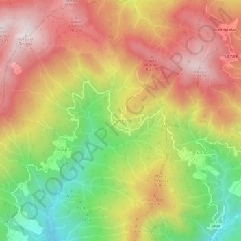
Nom : Carte topographique Pontito, altitude, relief.
Lieu : Pontito, Pescia, Pistoia, Tuscany, 51017, Italy (43.97762 10.70289 44.01762 10.74289)
Altitude moyenne : 756 m
Altitude minimum : 341 m
Altitude maximum : 1.114 m
Faire un don
Équipez-vous pour votre prochaine aventure :
En tant que Partenaire Amazon, ce site perçoit une commission sur les achats éligibles sans surcoût pour vous.