Géolocaliser

Carte topographique Taliparamba

Cliquez sur la carte pour afficher l’altitude.

Taliparamba

Taliparamba is located at 12°03′N 75°21′E / 12.05°N 75.35°E / 12.05; 75.35. It has an average elevation of 56 metres (184 ft) above sea level. The surrounding area (including the villages of Pattuvam, Pariyaram, Kuttiyeri, Karimbam, and Koonam) features lush green fields and low rolling hills. The Kuppam and Valapattanam rivers surround the town and the Arabian Sea is only 14 kilometres (8.7 mi) to the west of the city.

Wikipedia (CC-BY-SA 3.0)

À propos de cette carte

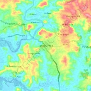
Nom : Carte topographique Taliparamba, altitude, relief.

Lieu : Taliparamba, Kannur, Kerala, 670141, India (11.99735 75.32028 12.07735 75.40028)

Altitude moyenne : 35 m

Altitude minimum : -2 m

Altitude maximum : 110 m

Autres cartes topographiques

Cliquez sur une carte pour visualiser sa topographie, son altitude et son relief.

Payyavoor

India > Kerala > Taliparamba > Payyavoor

Altitude moyenne : 221 m

Chengalayi

India > Kerala > Taliparamba > Chengalai > Parripayi

Altitude moyenne : 60 m

Nediyenga

India > Kerala > Taliparamba > Sreekandapuram

Altitude moyenne : 98 m

Valapattanam

India > Kerala > Taliparamba

Altitude moyenne : 86 m

Peruvangur

India > Kerala > Taliparamba > Mayyil

Altitude moyenne : 28 m

Kanakakunnu

India > Kerala > Taliparamba > Paithalmala

Altitude moyenne : 631 m

Cheleri

India > Kerala > Taliparamba

Altitude moyenne : 11 m

Poovanchal

India > Kerala > Taliparamba > Karthikapuram

Altitude moyenne : 178 m

Maniyoor

India > Kerala > Taliparamba > Cheruvathala Motta

Altitude moyenne : 35 m

Kaithapram

India > Kerala > Taliparamba > Sreekandapuram

Altitude moyenne : 35 m

Naduvil

India > Kerala > Taliparamba > Karuvanchal

Altitude moyenne : 288 m

Irikkur

India > Kerala > Taliparamba

Altitude moyenne : 332 m

Therthally

India > Kerala > Taliparamba > Therthalli

Altitude moyenne : 113 m

Équipez-vous pour votre prochaine aventure :

🛰️GPS Garmin randonnée - GPS Garmin reconnus pour la randonnée et le trekking
📱Supports smartphone vélo - Supports pour navigation GPS
🎒Sacs d'hydratation - Sacs avec poche à eau pour rester hydraté en mouvement
🕶️Lunettes de Soleil Sport - Protection UV pour les sommets et les plateaux dégagés
🧯Kits de survie - Équipement essentiel outdoor

En tant que Partenaire Amazon, ce site perçoit une commission sur les achats éligibles sans surcoût pour vous.