
Faire un don
Équipez-vous pour votre prochaine aventure :
En tant que Partenaire Amazon, ce site perçoit une commission sur les achats éligibles sans surcoût pour vous.
Carte topographique Handies Peak
Cliquez sur la carte pour afficher l’altitude.
Faire un don
Équipez-vous pour votre prochaine aventure :
En tant que Partenaire Amazon, ce site perçoit une commission sur les achats éligibles sans surcoût pour vous.
À propos de cette carte
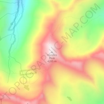
Nom : Carte topographique Handies Peak, altitude, relief.
Lieu : Handies Peak, Hinsdale County, Colorado, United States (37.91294 -107.50450 37.91304 -107.50440)
Altitude moyenne : 3.887 m
Altitude minimum : 3.481 m
Altitude maximum : 4.265 m
Faire un don
Équipez-vous pour votre prochaine aventure :
En tant que Partenaire Amazon, ce site perçoit une commission sur les achats éligibles sans surcoût pour vous.
Autres cartes topographiques
Cliquez sur une carte pour visualiser sa topographie, son altitude et son relief.
Lake City
United States > Colorado > Hinsdale County
Lake City experiences a continental climate (Köppen climate classification Dfb) that only just escapes being classified as semi-arid due to its relatively wet early springs and late autumns. On average, the wettest month is August, and the driest is February. Very large daily temperature swings are a regular…
Altitude moyenne : 2.834 m
Weminuche Wilderness
United States > Colorado > Hinsdale County
The Weminuche Wilderness is a wilderness area in southwest Colorado managed by the United States Forest Service as part of the San Juan National Forest on the west side of the Continental Divide and the Rio Grande National Forest on the east side of the divide. The Weminuche Wilderness was designated by…
Altitude moyenne : 3.059 m
Lake City
United States > Colorado > Hinsdale County
Lake City experiences a continental climate (Köppen climate classification Dfb) that only just escapes being classified as semi-arid due to its relatively wet early springs and late autumns. On average, the wettest month is August, and the driest is February. Very large daily temperature swings are a regular…
Altitude moyenne : 2.834 m
Faire un don
Équipez-vous pour votre prochaine aventure :
En tant que Partenaire Amazon, ce site perçoit une commission sur les achats éligibles sans surcoût pour vous.
Lake San Cristobal
United States > Colorado > Hinsdale County
Lake San Cristobal is a lake in the U.S. state of Colorado. Located in the San Juan Mountains at an elevation of 9,003 feet (2,744 m), the freshwater lake is 2.1 miles (3.4 km) long, up to 89 feet (27 m) deep, has a surface area of 0.52 square miles (1.3 km2), and holds about 11,000 acre-feet (14,000,000 m3)…
Altitude moyenne : 2.947 m