
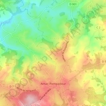
Carte topographique Arnac-Pompadour
Carte interactive
Cliquez sur la carte pour afficher l’altitude.
À propos de cette carte
Nom : Carte topographique Arnac-Pompadour, altitude, relief.
Altitude moyenne : 369 m
Altitude minimum : 280 m
Altitude maximum : 473 m
Autres cartes topographiques
Cliquez sur une carte pour visualiser sa topographie, son altitude et son relief.
Ligneyrac
France > Nouvelle-Aquitaine > Corrèze
Ligneyrac, Brive-la-Gaillarde, Corrèze, Nouvelle-Aquitaine, France métropolitaine, 19500, France
Altitude moyenne : 217 m
Montaignac-sur-Doustre
France > Nouvelle-Aquitaine > Corrèze
Montaignac-sur-Doustre, Ussel, Corrèze, Nouvelle-Aquitaine, France métropolitaine, 19300, France
Altitude moyenne : 594 m
La Nadalie
France > Nouvelle-Aquitaine > Corrèze > Saint-Pantaléon-de-Larche
La Nadalie, Saint-Pantaléon-de-Larche, Brive-la-Gaillarde, Corrèze, Nouvelle-Aquitaine, France métropolitaine, 19600, France
Altitude moyenne : 147 m
Jouix
France > Nouvelle-Aquitaine > Corrèze > Montaignac-sur-Doustre
Jouix, Montaignac-Saint-Hippolyte, Montaignac-sur-Doustre, Ussel, Corrèze, Nouvelle-Aquitaine, France métropolitaine, 19300, France
Altitude moyenne : 596 m
Chanac-les-Mines
France > Nouvelle-Aquitaine > Corrèze
Chanac-les-Mines, Tulle, Corrèze, Nouvelle-Aquitaine, France métropolitaine, 19150, France
Altitude moyenne : 374 m
Brive-la-Gaillarde
France > Nouvelle-Aquitaine > Corrèze
Brive-la-Gaillarde, Corrèze, Nouvelle-Aquitaine, France métropolitaine, 19100, France
Altitude moyenne : 178 m
Collonges-la-Rouge
France > Nouvelle-Aquitaine > Corrèze
Collonges-la-Rouge, Brive-la-Gaillarde, Corrèze, Nouvelle-Aquitaine, France métropolitaine, 19500, France
Altitude moyenne : 285 m
Saint-Aulaire
France > Nouvelle-Aquitaine > Corrèze
Saint-Aulaire, Brive-la-Gaillarde, Corrèze, Nouvelle-Aquitaine, France métropolitaine, 19130, France
Altitude moyenne : 158 m
Darazac
France > Nouvelle-Aquitaine > Corrèze
Darazac, Tulle, Corrèze, Nouvelle-Aquitaine, France métropolitaine, 19220, France
Altitude moyenne : 555 m
Eyrein
France > Nouvelle-Aquitaine > Corrèze
Eyrein, Tulle, Corrèze, Nouvelle-Aquitaine, France métropolitaine, 19800, France
Altitude moyenne : 576 m
Chamboulive
France > Nouvelle-Aquitaine > Corrèze
Chamboulive, Tulle, Corrèze, Nouvelle-Aquitaine, France métropolitaine, 19450, France
Altitude moyenne : 430 m
Palisse
France > Nouvelle-Aquitaine > Corrèze
Palisse, Ussel, Corrèze, Nouvelle-Aquitaine, France métropolitaine, 19160, France
Altitude moyenne : 634 m
Montgibaud
France > Nouvelle-Aquitaine > Corrèze
Montgibaud, Brive-la-Gaillarde, Corrèze, Nouvelle-Aquitaine, France métropolitaine, 19210, France
Altitude moyenne : 386 m
Margerides
France > Nouvelle-Aquitaine > Corrèze
Margerides, Ussel, Corrèze, Nouvelle-Aquitaine, France métropolitaine, 19200, France
Altitude moyenne : 639 m
Peyrissac
France > Nouvelle-Aquitaine > Corrèze
Peyrissac, Tulle, Corrèze, Nouvelle-Aquitaine, France métropolitaine, 19260, France
Altitude moyenne : 386 m
Estivaux
France > Nouvelle-Aquitaine > Corrèze
Estivaux, Brive-la-Gaillarde, Corrèze, Nouvelle-Aquitaine, France métropolitaine, 19410, France
Altitude moyenne : 340 m
Liginiac
France > Nouvelle-Aquitaine > Corrèze
Liginiac, Ussel, Corrèze, Nouvelle-Aquitaine, France métropolitaine, 19160, France
Altitude moyenne : 595 m
Saint-Bonnet-la-Rivière
France > Nouvelle-Aquitaine > Corrèze
Saint-Bonnet-la-Rivière, Brive-la-Gaillarde, Corrèze, Nouvelle-Aquitaine, France métropolitaine, 19130, France
Altitude moyenne : 188 m
Rosiers-de-Juillac
France > Nouvelle-Aquitaine > Corrèze
Rosiers-de-Juillac, Brive-la-Gaillarde, Corrèze, Nouvelle-Aquitaine, France métropolitaine, 19350, France
Altitude moyenne : 205 m
Saint-Clément
France > Nouvelle-Aquitaine > Corrèze
Saint-Clément, Tulle, Corrèze, Nouvelle-Aquitaine, France métropolitaine, 19700, France
Altitude moyenne : 432 m
Marcillac-la-Croisille
France > Nouvelle-Aquitaine > Corrèze
Marcillac-la-Croisille, Ussel, Corrèze, Nouvelle-Aquitaine, France métropolitaine, 19320, France
Altitude moyenne : 527 m
Laurière
France > Nouvelle-Aquitaine > Corrèze > Meilhards
Laurière, Meilhards, Tulle, Corrèze, Nouvelle-Aquitaine, France métropolitaine, 19510, France
Altitude moyenne : 484 m
Grandsaigne
France > Nouvelle-Aquitaine > Corrèze
Grandsaigne, Tulle, Corrèze, Nouvelle-Aquitaine, France métropolitaine, 19300, France
Altitude moyenne : 715 m
Pradines
France > Nouvelle-Aquitaine > Corrèze
Pradines, Tulle, Corrèze, Nouvelle-Aquitaine, France métropolitaine, 19170, France
Altitude moyenne : 762 m
Bonnefond
France > Nouvelle-Aquitaine > Corrèze
Bonnefond, Tulle, Corrèze, Nouvelle-Aquitaine, France métropolitaine, 19170, France
Altitude moyenne : 827 m
Uzerche
France > Nouvelle-Aquitaine > Corrèze
Uzerche, Tulle, Corrèze, Nouvelle-Aquitaine, France métropolitaine, 19140, France
Altitude moyenne : 371 m
Lamazière-Basse
France > Nouvelle-Aquitaine > Corrèze
Lamazière-Basse, Ussel, Corrèze, Nouvelle-Aquitaine, France métropolitaine, 19160, France
Altitude moyenne : 570 m
Saint-Viance
France > Nouvelle-Aquitaine > Corrèze
Saint-Viance, Brive-la-Gaillarde, Corrèze, Nouvelle-Aquitaine, France métropolitaine, 19240, France
Altitude moyenne : 135 m
Peyrelevade
France > Nouvelle-Aquitaine > Corrèze
Peyrelevade, Ussel, Corrèze, Nouvelle-Aquitaine, France métropolitaine, 19290, France
Altitude moyenne : 824 m
Salon-la-Tour
France > Nouvelle-Aquitaine > Corrèze
Salon-la-Tour, Tulle, Corrèze, Nouvelle-Aquitaine, France métropolitaine, 19510, France
Altitude moyenne : 415 m
Madranges
France > Nouvelle-Aquitaine > Corrèze
Madranges, Tulle, Corrèze, Nouvelle-Aquitaine, France métropolitaine, 19470, France
Altitude moyenne : 563 m
Gourdon-Murat
France > Nouvelle-Aquitaine > Corrèze
Gourdon-Murat, Tulle, Corrèze, Nouvelle-Aquitaine, France métropolitaine, 19170, France
Altitude moyenne : 756 m
Lacelle
France > Nouvelle-Aquitaine > Corrèze
Lacelle, Tulle, Corrèze, Nouvelle-Aquitaine, France métropolitaine, 19170, France
Altitude moyenne : 666 m
Saint-Hilaire-les-Courbes
France > Nouvelle-Aquitaine > Corrèze
Saint-Hilaire-les-Courbes, Tulle, Corrèze, Nouvelle-Aquitaine, France métropolitaine, 19170, France
Altitude moyenne : 649 m
L'Église-aux-Bois
France > Nouvelle-Aquitaine > Corrèze
L'Église-aux-Bois, Tulle, Corrèze, Nouvelle-Aquitaine, France métropolitaine, 19170, France
Altitude moyenne : 652 m
Saint-Augustin
France > Nouvelle-Aquitaine > Corrèze
Saint-Augustin, Tulle, Corrèze, Nouvelle-Aquitaine, France métropolitaine, 19390, France
Altitude moyenne : 592 m
Veix
France > Nouvelle-Aquitaine > Corrèze
Veix, Tulle, Corrèze, Nouvelle-Aquitaine, France métropolitaine, 19260, France
Altitude moyenne : 679 m
Toy-Viam
France > Nouvelle-Aquitaine > Corrèze
Toy-Viam, Tulle, Corrèze, Nouvelle-Aquitaine, France métropolitaine, 19170, France
Altitude moyenne : 737 m
Meilhards
France > Nouvelle-Aquitaine > Corrèze
Meilhards, Tulle, Corrèze, Nouvelle-Aquitaine, France métropolitaine, 19510, France
Altitude moyenne : 457 m
Lamongerie
France > Nouvelle-Aquitaine > Corrèze
Lamongerie, Tulle, Corrèze, Nouvelle-Aquitaine, France métropolitaine, 19510, France
Altitude moyenne : 439 m
La Croix
France > Nouvelle-Aquitaine > Corrèze > Vignols
La Croix, Vignols, Brive-la-Gaillarde, Corrèze, Nouvelle-Aquitaine, France métropolitaine, 19130, France
Altitude moyenne : 280 m
Treignac
France > Nouvelle-Aquitaine > Corrèze
Treignac, Tulle, Corrèze, Nouvelle-Aquitaine, France métropolitaine, 19260, France
Altitude moyenne : 545 m
Bugeat
France > Nouvelle-Aquitaine > Corrèze
Bugeat, Ussel, Corrèze, Nouvelle-Aquitaine, France métropolitaine, 19170, France
Altitude moyenne : 739 m
Lestards
France > Nouvelle-Aquitaine > Corrèze
Lestards, Tulle, Corrèze, Nouvelle-Aquitaine, France métropolitaine, 19170, France
Altitude moyenne : 708 m
Tarnac
France > Nouvelle-Aquitaine > Corrèze
Tarnac, Tulle, Corrèze, Nouvelle-Aquitaine, France métropolitaine, 19170, France
Altitude moyenne : 732 m
Mont Bessou
France > Nouvelle-Aquitaine > Corrèze > Meymac
Mont Bessou, Meymac, Ussel, Corrèze, Nouvelle-Aquitaine, France métropolitaine, 19250, France
Altitude moyenne : 859 m
Remeniéras
France > Nouvelle-Aquitaine > Corrèze > Chamberet
Remeniéras, Chamberet, Tulle, Corrèze, Nouvelle-Aquitaine, France métropolitaine, 19370, France
Altitude moyenne : 592 m
Viers
France > Nouvelle-Aquitaine > Corrèze > Corrèze
Viers, Corrèze, Tulle, Corrèze, Nouvelle-Aquitaine, France métropolitaine, 19800, France
Altitude moyenne : 458 m
Cosnac
France > Nouvelle-Aquitaine > Corrèze > Cosnac
Cosnac, Brive-la-Gaillarde, Corrèze, Nouvelle-Aquitaine, France métropolitaine, 19360, France
Altitude moyenne : 234 m
Le Breuil
France > Nouvelle-Aquitaine > Corrèze > Collonges-la-Rouge
Le Breuil, Collonges-la-Rouge, Brive-la-Gaillarde, Corrèze, Nouvelle-Aquitaine, France métropolitaine, 19500, France
Altitude moyenne : 225 m