
Carte topographique Summit County
Carte interactive
Cliquez sur la carte pour afficher l’altitude.
À propos de cette carte
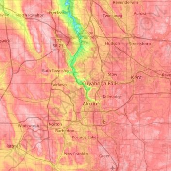
Nom : Carte topographique Summit County, altitude, relief.
Lieu : Summit County, Ohio, United States of America (40.90650 -81.68849 41.35113 -81.39169)
Altitude moyenne : 327 m
Altitude minimum : 187 m
Altitude maximum : 405 m
Summit County is an urban county in the U.S. state of Ohio. As of the 2010 census, the population was 541,781 making it the fourth-most populous county in Ohio. Its county seat is Akron. The county was formed on March 3, 1840, from portions of Medina, Portage and Stark Counties. It was named "Summit County" because the highest elevation on the Ohio and Erie Canal is located in the county.
Autres cartes topographiques
Cliquez sur une carte pour visualiser sa topographie, son altitude et son relief.
Parma
United States of America > Ohio > Parma
Parma, Cuyahoga County, Ohio, United States of America
Altitude moyenne : 282 m
Rocky River
United States of America > Ohio > Rocky River
Rocky River, Cuyahoga County, Ohio, 44116, United States of America
Altitude moyenne : 205 m
Glouster
United States of America > Ohio > Glouster
Glouster, Athens County, Ohio, 45732, United States of America
Altitude moyenne : 235 m
Ross County
United States of America > Ohio
Ross County, Ohio, United States of America
Altitude moyenne : 257 m