
Faire un don
Équipez-vous pour votre prochaine aventure :
En tant que Partenaire Amazon, ce site perçoit une commission sur les achats éligibles sans surcoût pour vous.
Carte topographique Almota
Cliquez sur la carte pour afficher l’altitude.
Faire un don
Équipez-vous pour votre prochaine aventure :
En tant que Partenaire Amazon, ce site perçoit une commission sur les achats éligibles sans surcoût pour vous.
À propos de cette carte
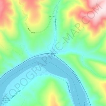
Nom : Carte topographique Almota, altitude, relief.
Lieu : Almota, Whitman County, Washington, United States (46.68335 -117.48744 46.72335 -117.44744)
Altitude moyenne : 339 m
Altitude minimum : 190 m
Altitude maximum : 663 m
Faire un don
Équipez-vous pour votre prochaine aventure :
En tant que Partenaire Amazon, ce site perçoit une commission sur les achats éligibles sans surcoût pour vous.
Autres cartes topographiques
Cliquez sur une carte pour visualiser sa topographie, son altitude et son relief.
Pullman
United States > Washington > Whitman County
Pullman is situated within the Palouse region, characterized by its distinct topography of rolling hills formed from loess deposits—windblown silt accumulated over millennia. The city's average elevation is approximately 2,540 feet (774 meters), with elevations ranging from about 2,342 to 2,575 feet (714 to…
Altitude moyenne : 774 m
Faire un don
Équipez-vous pour votre prochaine aventure :
En tant que Partenaire Amazon, ce site perçoit une commission sur les achats éligibles sans surcoût pour vous.
Pullman
United States > Washington > Whitman County
The city is situated across several loess hills which characterize the Palouse Prairie, formed from windblown sediment over an estimated period of over one million years. This prairie region, the Palouse, is noteworthy for its fertile rolling hills where winter and spring wheat, barley, canola, lentils, and…
Altitude moyenne : 773 m
Pullman
United States > Washington > Whitman County
The city is situated across several loess hills which characterize the Palouse Prairie, formed from windblown sediment over an estimated period of over one million years. This prairie region, the Palouse, is noteworthy for its fertile rolling hills where winter and spring wheat, barley, canola, lentils, and…
Altitude moyenne : 774 m
Faire un don
Équipez-vous pour votre prochaine aventure :
En tant que Partenaire Amazon, ce site perçoit une commission sur les achats éligibles sans surcoût pour vous.
Pullman
United States > Washington > Whitman County
The city is situated across several loess hills which characterize the Palouse Prairie, formed from windblown sediment over an estimated period of over one million years. This prairie region, the Palouse, is noteworthy for its fertile rolling hills where winter and spring wheat, barley, canola, lentils, and…
Altitude moyenne : 774 m