Géolocaliser

Carte topographique Mount Lofty

Cliquez sur la carte pour afficher l’altitude.

À propos de cette carte

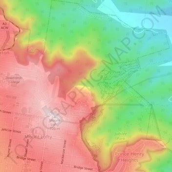
Nom : Carte topographique Mount Lofty, altitude, relief.

Lieu : Mount Lofty, Toowoomba, Toowoomba Regional, Queensland, Australia (-27.55584 151.96341 -27.51802 151.99928)

Altitude moyenne : 513 m

Altitude minimum : 283 m

Altitude maximum : 719 m

Autres cartes topographiques

Cliquez sur une carte pour visualiser sa topographie, son altitude et son relief.

Ravensbourne

Australia > Queensland > Toowoomba

Altitude moyenne : 583 m

Mount Lofty

Australia > Queensland > Toowoomba

Altitude moyenne : 614 m

Toowoomba City

Australia > Queensland > Toowoomba

Altitude moyenne : 615 m

Picnic Point

Australia > Queensland > Toowoomba

The first addition to the Picnic Point Reserve was made when the Municipal Council purchased two freehold allotments fronting both Heller and Rowbotham Streets in 1902. By 1906 the council had commenced tree-planting at Picnic Point under the supervision of Curator Harding of the Botanical gardens. A further…

Altitude moyenne : 575 m

Glenvale

Australia > Queensland > Toowoomba

Altitude moyenne : 565 m

Cawdor

Australia > Queensland > Toowoomba

Altitude moyenne : 574 m

West Creek Park

Australia > Queensland > Toowoomba

Altitude moyenne : 652 m

Captain Cook Reserve

Australia > Queensland > Toowoomba

Altitude moyenne : 635 m

Lookout

Australia > Queensland > Toowoomba

Altitude moyenne : 548 m

Équipez-vous pour votre prochaine aventure :

🔦Lampes Frontales LED - Éclairage mains libres pour vos explorations nocturnes
🪶Ponchos de pluie - Protection légère contre la pluie
Montres GPS randonnée - Montres robustes pour navigation et suivi outdoor
🧴Protections Solaires - Indispensable lors des longues expositions en altitude
Montres de Sport GPS - Données topographiques directement au poignet

En tant que Partenaire Amazon, ce site perçoit une commission sur les achats éligibles sans surcoût pour vous.