
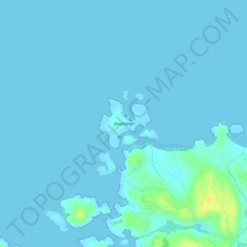
Carte topographique Inishinny
Carte interactive
Cliquez sur la carte pour afficher l’altitude.
À propos de cette carte
Nom : Carte topographique Inishinny, altitude, relief.
Altitude moyenne : 2 m
Altitude minimum : -2 m
Altitude maximum : 23 m
Autres cartes topographiques
Cliquez sur une carte pour visualiser sa topographie, son altitude et son relief.
Ballybrack
Ballybrack, Moville ED, Inishowen Municipal District, County Donegal, Ireland
Altitude moyenne : 147 m
Kiltole
Kiltole, Figart ED, Lifford-Stranorlar Municipal District, County Donegal, Ireland
Altitude moyenne : 49 m
Teelin
Teelin, Donegal Municipal District, County Donegal, Ireland
Altitude moyenne : 88 m
Rathmullan
Rathmullan, County Donegal, F92 DH90, Ireland
Altitude moyenne : 19 m
Carn Hill
Ireland > County Donegal > Letterkenny
Carn Hill, Letterkenny, County Donegal, F92 W8CY, Ireland
Altitude moyenne : 144 m
Lisnenan
Ireland > County Donegal > Letterkenny
Lisnenan, Letterkenny Rural ED, Letterkenny, County Donegal, F92 W8CY, Ireland
Altitude moyenne : 101 m
Glencar Scotch
Ireland > County Donegal > Letterkenny
Glencar Scotch, Letterkenny Rural ED, Letterkenny, County Donegal, Ireland
Altitude moyenne : 134 m
Trillick
Trillick, Buncrana Rural ED, Inishowen Municipal District, County Donegal, Ulster, Ireland
Altitude moyenne : 106 m
Letterkenny
Ireland > County Donegal > Letterkenny
Letterkenny, Letterkenny Municipal District, County Donegal, F92 PD92, Ireland
Altitude moyenne : 93 m
Glen Lough
Ireland > County Donegal > Letterkenny
Glen Lough, Millford ED, Letterkenny, County Donegal, Ulster, Ireland
Altitude moyenne : 89 m
Stragraddy
Ireland > County Donegal > Letterkenny
Stragraddy, Termon ED, Letterkenny, County Donegal, Ulster, Ireland
Altitude moyenne : 118 m
Donegal Bay
Donegal Bay, County Donegal, Ulster, Ireland
Altitude moyenne : 38 m
Church Hill
Ireland > County Donegal > Letterkenny
Church Hill, Church Hill ED, Letterkenny, County Donegal, Ireland
Altitude moyenne : 117 m
Gortahork
Gortahork, Gleneely ED, Lifford-Stranorlar Municipal District, County Donegal, Ireland
Altitude moyenne : 173 m
Bomany
Ireland > County Donegal > Letterkenny
Bomany, Ballymacool ED, Letterkenny, County Donegal, Ulster, Ireland
Altitude moyenne : 62 m
Murvagh Upper Glebe
Murvagh Upper Glebe, Ballintra ED, Donegal Municipal District, County Donegal, Ireland
Altitude moyenne : 7 m
Inver Glebe
Inver Glebe, Inver ED, Donegal Municipal District, County Donegal, Ireland
Altitude moyenne : 26 m
Castlefinn
Castlefinn, Castlefinn ED, Lifford-Stranorlar Municipal District, County Donegal, Ulster, Ireland
Altitude moyenne : 27 m
Inishowen Municipal District
Inishowen Municipal District, County Donegal, Ireland
Altitude moyenne : 59 m
Moness
Moness, Burt ED, Inishowen Municipal District, County Donegal, Ireland
Altitude moyenne : 53 m
Moness
Moness, St Johnstown Electoral Division, Lifford-Stranorlar Municipal District, County Donegal, Ireland
Altitude moyenne : 55 m
Toulett
Toulett, Burt ED, Inishowen Municipal District, County Donegal, Ireland
Altitude moyenne : 89 m
Sallaghagrane
Ireland > County Donegal > Letterkenny
Sallaghagrane, Letterkenny Rural ED, Letterkenny, County Donegal, Ulster, Ireland
Altitude moyenne : 57 m
Dungloe River
Dungloe River, Dunglow ED, Glenties Municipal District, County Donegal, Ulster, F94 W974, Ireland
Altitude moyenne : 24 m
Murvagh Beach
Murvagh Beach, Ballintra ED, Donegal Municipal District, County Donegal, Ireland
Altitude moyenne : 2 m
Cashel
Cashel, Donegal Municipal District, County Donegal, Ireland
Altitude moyenne : 108 m
Inishowen
Inishowen, Dawros ED, Glenties Municipal District, County Donegal, Ireland
Altitude moyenne : 13 m
Lifford-Stranorlar Municipal District
Lifford-Stranorlar Municipal District, County Donegal, Ulster, Ireland
Altitude moyenne : 142 m
Cark
Cark, Lettermore ED, Lifford-Stranorlar Municipal District, County Donegal, Ireland
Altitude moyenne : 256 m
Tory Island
Tory Island, Meenaclady, Glenties Municipal District, County Donegal, Ireland
Altitude moyenne : 3 m
Horn Head
Horn Head, Dunfanaghy Electoral Division, Glenties Municipal District, County Donegal, F92 H0CY, Ireland
Altitude moyenne : 31 m
Creeslough ED
Creeslough ED, Glenties Municipal District, County Donegal, Ulster, F92 W803, Ireland
Altitude moyenne : 43 m
Kilmacrennan
Ireland > County Donegal > Kilmacrennan
Kilmacrennan, Letterkenny Municipal District, County Donegal, Ireland
Altitude moyenne : 63 m
Drumaneary
Drumaneary, Tantallon ED, Donegal Municipal District, County Donegal, Ireland
Altitude moyenne : 23 m
Gortnamuck
Gortnamuck, Cloghard ED, Lifford-Stranorlar Municipal District, County Donegal, Ireland
Altitude moyenne : 87 m
Melmore Head
Ireland > County Donegal > Letterkenny
Melmore Head, Atlantic Way, Rosguill ED, Letterkenny, County Donegal, Ireland
Altitude moyenne : 9 m
Drumnacross
Drumnacross, Ardara ED, Glenties Municipal District, County Donegal, Ireland
Altitude moyenne : 88 m
Donegal Municipal District
Donegal Municipal District, County Donegal, Ulster, Ireland
Altitude moyenne : 120 m
Dunduffsfort
Dunduffsfort, Newtown Cunningham ED, Inishowen Municipal District, County Donegal, Ireland
Altitude moyenne : 76 m
Kildoney Glebe
Kildoney Glebe, Ballyshannon Rural ED, Donegal Municipal District, County Donegal, Ireland
Altitude moyenne : 13 m
Ballyargus
Ballyargus, Redcastle ED, Inishowen Municipal District, County Donegal, Ireland
Altitude moyenne : 169 m
Duncap Isle
Duncap Isle, Dunfanaghy Electoral Division, Glenties Municipal District, County Donegal, F92 H0CY, Ireland
Altitude moyenne : 38 m
Dunglow
Dunglow, Dunglow ED, Glenties Municipal District, County Donegal, Ulster, Ireland
Altitude moyenne : 26 m
Lough Derryduff
Lough Derryduff, Maas ED, Glenties Municipal District, County Donegal, Ireland
Altitude moyenne : 41 m
Largynagreana
Largynagreana, Killybegs ED, Donegal Municipal District, County Donegal, Ireland
Altitude moyenne : 93 m
Speenoge
Speenoge, Burt ED, Inishowen Municipal District, County Donegal, Ireland
Altitude moyenne : 79 m
Cullion
Cullion, Lettermacaward ED, Glenties Municipal District, County Donegal, Ireland
Altitude moyenne : 29 m