
Carte topographique Talgar
Carte interactive
Cliquez sur la carte pour afficher l’altitude.
À propos de cette carte
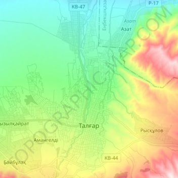
Nom : Carte topographique Talgar, altitude, relief.
Lieu : Talgar, Talgar District, Almaty Region, Kazakhstan (43.27599 77.19138 43.36656 77.26641)
Altitude moyenne : 980 m
Altitude minimum : 771 m
Altitude maximum : 1.399 m
Talgar has a total area of 18.8 square km (7.3 mi²). The grade of the town's built-up areas is consistent with the natural unevenness of its overall natural geography. The average land elevation is 1250 m above sea level. The lowest points are in the northern part of the town at 1000 m, while the highest points at 1500 m are located in the town's south side.