
Faire un don
Équipez-vous pour votre prochaine aventure :
En tant que Partenaire Amazon, ce site perçoit une commission sur les achats éligibles sans surcoût pour vous.
Carte topographique Waginger See
Cliquez sur la carte pour afficher l’altitude.
Faire un don
Équipez-vous pour votre prochaine aventure :
En tant que Partenaire Amazon, ce site perçoit une commission sur les achats éligibles sans surcoût pour vous.
Waginger See
Waginger See is a lake in the Alpine foothills, Bavaria, Germany. Geologically, it forms one single lake with the Tachinger See, with which it is connected through a narrow strait at Tettenhausen. The surface area of the Waginger See proper is 6.61 km2 (2.55 sq mi); combined with the Tachinger See it is 8.97 km2 (3.46 sq mi). Its elevation is 441 m (1,447 ft) and its drainage area is 163.66 km2 (63.19 sq mi). Its primary inflows are Schinderbach, Höllenbach and Tenglinger Bach, and it is drained by the Götzinger Achen.
Faire un don
Équipez-vous pour votre prochaine aventure :
En tant que Partenaire Amazon, ce site perçoit une commission sur les achats éligibles sans surcoût pour vous.
À propos de cette carte
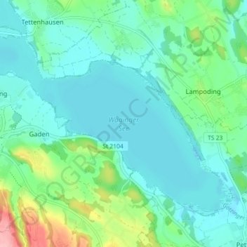
Nom : Carte topographique Waginger See, altitude, relief.
Altitude moyenne : 464 m
Altitude minimum : 437 m
Altitude maximum : 565 m
Faire un don
Équipez-vous pour votre prochaine aventure :
En tant que Partenaire Amazon, ce site perçoit une commission sur les achats éligibles sans surcoût pour vous.