
Faire un don
Équipez-vous pour votre prochaine aventure :
En tant que Partenaire Amazon, ce site perçoit une commission sur les achats éligibles sans surcoût pour vous.
Carte topographique Juist
Cliquez sur la carte pour afficher l’altitude.
Faire un don
Équipez-vous pour votre prochaine aventure :
En tant que Partenaire Amazon, ce site perçoit une commission sur les achats éligibles sans surcoût pour vous.
Juist
Juist is accessible by plane or daily ferry. FLN Frisia Luftverkehr operates planes between Norden and Juist. Most motor vehicles are prohibited on the island, with only the fire department, the German Red Cross and doctors allowed to use them. Island tractors require a special license, while most other transport is done by bike or horse-drawn carriage. It was reported by the Reuters news agency, on 24 September 2014, that an unmanned "parcelcopter" will commence delivery of urgent drugs and supplies to the island by DHL. It will be the first time an unmanned aircraft had been authorised to deliver goods in Europe and the first time that automated drones have been used to deliver medicines anywhere in the world. The flight at an altitude of 50 m and at a speed of up to 18 m/s will be automated but monitored in Norddeich.
Faire un don
Équipez-vous pour votre prochaine aventure :
En tant que Partenaire Amazon, ce site perçoit une commission sur les achats éligibles sans surcoût pour vous.
À propos de cette carte
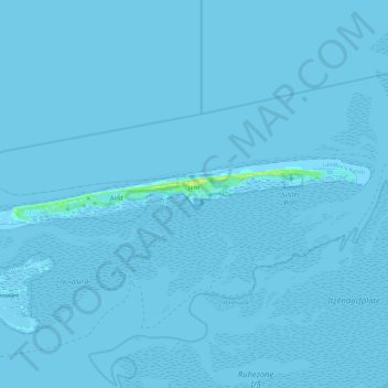
Nom : Carte topographique Juist, altitude, relief.
Lieu : Juist, Landkreis Aurich, Lower Saxony, 26571, Germany (53.66273 6.86500 53.68875 7.10509)
Altitude moyenne : 0 m
Altitude minimum : -4 m
Altitude maximum : 16 m
Faire un don
Équipez-vous pour votre prochaine aventure :
En tant que Partenaire Amazon, ce site perçoit une commission sur les achats éligibles sans surcoût pour vous.
Autres cartes topographiques
Cliquez sur une carte pour visualiser sa topographie, son altitude et son relief.
Faire un don
Équipez-vous pour votre prochaine aventure :
En tant que Partenaire Amazon, ce site perçoit une commission sur les achats éligibles sans surcoût pour vous.