Géolocaliser

Carte topographique Swalecliffe

Cliquez sur la carte pour afficher l’altitude.

👉 Easily get elevation data in JSON, GeoTIFF and KML formats using Elevation API
Merci de soutenir ce site ❤️
Faire un don

Équipez-vous pour votre prochaine aventure :

En tant que Partenaire Amazon, ce site perçoit une commission sur les achats éligibles sans surcoût pour vous.

À propos de cette carte

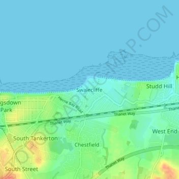
Nom : Carte topographique Swalecliffe, altitude, relief.

Lieu : Swalecliffe, Canterbury, Kent, England, CT5 2NX, United Kingdom (51.34604 1.04819 51.38604 1.08819)

Altitude moyenne : 8 m

Altitude minimum : 0 m

Altitude maximum : 41 m

Autres cartes topographiques

Cliquez sur une carte pour visualiser sa topographie, son altitude et son relief.

Kingston

United Kingdom > England > Kent > Canterbury

Altitude moyenne : 84 m

Hoath

United Kingdom > England > Kent > Canterbury

Altitude moyenne : 24 m

Sturry

United Kingdom > England > Kent > Canterbury

Altitude moyenne : 32 m

Chartham

United Kingdom > England > Kent > Canterbury

Altitude moyenne : 60 m

Westbere

United Kingdom > England > Kent > Canterbury

Altitude moyenne : 21 m

Waltham

United Kingdom > England > Kent > Canterbury

Altitude moyenne : 127 m

Petham

United Kingdom > England > Kent > Canterbury > Petham

Altitude moyenne : 96 m

Chestfield

United Kingdom > England > Kent > Canterbury

Altitude moyenne : 34 m

Littlebourne

United Kingdom > England > Kent > Canterbury

Altitude moyenne : 21 m

Bishopsbourne

United Kingdom > England > Kent > Canterbury > Bishopsbourne

Altitude moyenne : 79 m

Wickhambreaux

United Kingdom > England > Kent > Canterbury

Altitude moyenne : 13 m

Upper Hardres

United Kingdom > England > Kent > Canterbury

Altitude moyenne : 120 m

Hersden

United Kingdom > England > Kent > Canterbury

Altitude moyenne : 19 m

Barham

United Kingdom > England > Kent > Canterbury

Altitude moyenne : 99 m

Adisham

United Kingdom > England > Kent > Canterbury

Altitude moyenne : 63 m

Thanington

United Kingdom > England > Kent > Canterbury

Altitude moyenne : 49 m

Fordwich

United Kingdom > England > Kent > Canterbury

Altitude moyenne : 25 m

Kingston

United Kingdom > England > Kent > Canterbury

Altitude moyenne : 84 m

Équipez-vous pour votre prochaine aventure :

🚲Compteurs Vélo GPS - Tracez vos itinéraires et analysez les pentes gravies
📏Podomètres Précis - Mesurez vos distances parcourues lors de vos explorations
🧼Savons biodégradables - Hygiène respectueuse de la nature
🪶Ponchos de pluie - Protection légère contre la pluie
🌍Globes terrestres - Visualisation géographique

En tant que Partenaire Amazon, ce site perçoit une commission sur les achats éligibles sans surcoût pour vous.