
Carte topographique Thunder Bay District
Carte interactive
Cliquez sur la carte pour afficher l’altitude.
À propos de cette carte
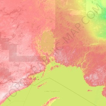
Nom : Carte topographique Thunder Bay District, altitude, relief.
Lieu : Thunder Bay District, Ontario, Canadá (47.07941 -91.00791 51.55303 -85.31837)
Altitude moyenne : 313 m
Altitude minimum : 97 m
Altitude maximum : 657 m
Autres cartes topographiques
Cliquez sur une carte pour visualiser sa topographie, son altitude et son relief.
Peterborough
Canadá > Ontario > Peterborough
Peterborough, Central Ontario, Ontario, K9H 7E8, Canadá
Altitude moyenne : 235 m
Richmond Hill
Canadá > Ontario > Richmond Hill
Richmond Hill, York Region, Golden Horseshoe, Ontario, Canadá
Altitude moyenne : 256 m
Grand River
Grand River, Wellington County, Southwestern Ontario, Ontario, N0B 2V0, Canadá
Altitude moyenne : 300 m
Carleton Place
Canadá > Ontario > Carleton Place
Carleton Place, Lanark County, Eastern Ontario, Ontario, Canadá
Altitude moyenne : 137 m
Victoria Island
Victoria Island, (Old) Ottawa, Ottawa, Ontario, K1R 1C5, Canadá
Altitude moyenne : 126 m
Manitoulin Island
Canadá > Ontario > Northeastern Manitoulin and the Islands
Manitoulin Island, Northeastern Manitoulin and the Islands, Manitoulin District, Ontario, Canadá
Altitude moyenne : 202 m
Lago Nipigon
Canadá > Ontario > Unorganized Thunder Bay District
Lago Nipigon, Unorganized Thunder Bay District, Thunder Bay District, Northwestern Ontario, Ontario, Canadá
Altitude moyenne : 307 m
Windermere Lake
Canadá > Ontario > Unorganized South Nipissing
Windermere Lake, Unorganized South Nipissing, Nipissing District, Ontario, Canadá
Altitude moyenne : 355 m
Lake Simcoe
Canadá > Ontario > Oro-Medonte
Lake Simcoe, Oro-Medonte, Simcoe County, Central Ontario, Ontario, L3Y 7C1, Canadá
Altitude moyenne : 247 m
Lago de los Bosques
Canadá > Ontario > Lake of the Woods
Lago de los Bosques, Lake of the Woods, Rainy River District, Northwestern Ontario, Ontario, P0X 1C0, Canadá
Altitude moyenne : 337 m
Lago Ontario
Canadá > Ontario > Quinte West
Lago Ontario, Quinte West, Central Ontario, Ontario, Canadá
Altitude moyenne : 215 m