
Carte topographique Tomtit Lake
Carte interactive
Cliquez sur la carte pour afficher l’altitude.
À propos de cette carte
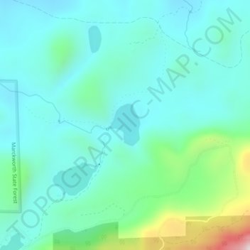
Nom : Carte topographique Tomtit Lake, altitude, relief.
Lieu : Tomtit Lake, Snohomish County, Washington, United States (47.81691 -121.78991 47.82148 -121.78428)
Altitude moyenne : 272 m
Altitude minimum : 148 m
Altitude maximum : 779 m
Autres cartes topographiques
Cliquez sur une carte pour visualiser sa topographie, son altitude et son relief.
Index
United States > Washington > Snohomish County
Index, Snohomish County, Washington, United States
Altitude moyenne : 366 m
Mill Creek
United States > Washington > Snohomish County
Mill Creek, Snohomish County, Washington, United States
Altitude moyenne : 130 m
Sultan
United States > Washington > Snohomish County
Sultan, Snohomish County, Washington, 98294, United States
Altitude moyenne : 78 m
Sulphur Mountain
United States > Washington > Snohomish County
Sulphur Mountain, Snohomish County, Washington, United States
Altitude moyenne : 1.628 m
Pass Lake
United States > Washington > Snohomish County
Pass Lake, Snohomish County, Washington, United States
Altitude moyenne : 1.167 m
Marysville
United States > Washington > Snohomish County
Marysville, Snohomish County, Washington, United States
Altitude moyenne : 72 m
Edmonds
United States > Washington > Snohomish County
Edmonds, Snohomish County, Washington, United States
Altitude moyenne : 44 m
Lake Ketchum
United States > Washington > Snohomish County > Lake Ketchum
Lake Ketchum, Snohomish County, Washington, United States
Altitude moyenne : 56 m
Monroe
United States > Washington > Snohomish County
Monroe, Snohomish County, Washington, 98272, United States
Altitude moyenne : 49 m
Everett
United States > Washington > Snohomish County
Everett, Snohomish County, Washington, United States
Altitude moyenne : 69 m