
Carte topographique Marathon
Cliquez sur la carte pour afficher l’altitude.
À propos de cette carte
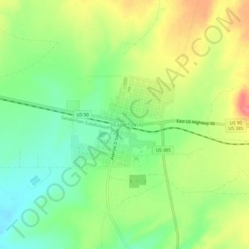
Nom : Carte topographique Marathon, altitude, relief.
Lieu : Marathon, Brewster County, Texas, 79842, United States (30.18596 -103.26456 30.22596 -103.22456)
Altitude moyenne : 1.244 m
Altitude minimum : 1.212 m
Altitude maximum : 1.285 m
Autres cartes topographiques
Cliquez sur une carte pour visualiser sa topographie, son altitude et son relief.
Alpine
United States > Texas > Brewster County
Alpine (/ˈælpaɪn/ AL-pyne) is a city in the county seat of Brewster County, Texas, United States. The population was 5,905 at the 2010 census. The town has an elevation of 4,475 feet (1,364 m), and the surrounding mountain peaks are over 1 mile (1.6 km) above sea level. The university, hospital, library,…
Altitude moyenne : 1.373 m
Big Bend National Park
United States > Texas > Brewster County
Big Bend National Park is an American national park located in West Texas, bordering Mexico. The park has national significance as the largest protected area of Chihuahuan Desert topography and ecology in the United States, and was named after a large bend in the Rio Grande/Río Bravo. The park protects more…
Altitude moyenne : 934 m
Alpine
United States > Texas > Brewster County
Alpine (/ˈælpaɪn/ AL-pyne) is a city in and the county seat of Brewster County, Texas, United States. The population was 6,035 at the 2020 census. The town has an elevation of 4,462 feet (1,360 m), and the surrounding mountain peaks are over 1 mile (1.6 km) above sea level. A university, hospital, library,…
Altitude moyenne : 1.373 m