
Carte topographique Innertkirchen
Carte interactive
Cliquez sur la carte pour afficher l’altitude.
Innertkirchen
The large alpine municipality is located at the confluence of the Urbach and Gadmer streams into the Aare river. It includes the Urbach valley, the Gadmen valley, the Gen valley, the Wetterhorn mountain and the Gauli Glacier. Innertkirchen was created out of the Bäuerten (farming communities) of Grund, Bottigen, Wyler-Schattseite, Wyler-Sonnseite and the agricultural cooperative of Äppigen in 1834. The merger with Gadmen almost doubled the size the municipality. Gadmen lies in the Bernese Oberland with the Susten Pass on the eastern border of the former municipality. The municipal borders stretch from the valley floor, with an elevation of 850–1,250 m (2,790–4,100 ft), up to the nearby mountain peaks at about 3,500 m (11,500 ft). It is located on the border of the Canton of Bern with the Cantons of Obwalden, Nidwalden, Uri and Valais.
À propos de cette carte
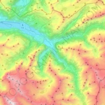
Nom : Carte topographique Innertkirchen, altitude, relief.
Altitude moyenne : 1.945 m
Altitude minimum : 570 m
Altitude maximum : 4.023 m
Autres cartes topographiques
Cliquez sur une carte pour visualiser sa topographie, son altitude et son relief.
Triftsee
Switzerland > Bern > Interlaken-Oberhasli administrative district > Innertkirchen
Altitude moyenne : 2.025 m
Underburg
Switzerland > Bern > Interlaken-Oberhasli administrative district > Innertkirchen > Wychel
Altitude moyenne : 912 m
Wychel
Switzerland > Bern > Interlaken-Oberhasli administrative district > Innertkirchen
Altitude moyenne : 992 m
Spis
Switzerland > Bern > Interlaken-Oberhasli administrative district > Innertkirchen > Äppigen
Altitude moyenne : 871 m
Underburg
Switzerland > Bern > Interlaken-Oberhasli administrative district > Innertkirchen > Wychel
Altitude moyenne : 912 m
Titlis
Switzerland > Bern > Interlaken-Oberhasli administrative district > Innertkirchen
Altitude moyenne : 2.520 m