
Carte topographique Village of Menands
Carte interactive
Cliquez sur la carte pour afficher l’altitude.
À propos de cette carte
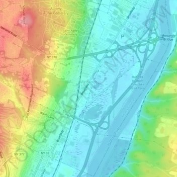
Nom : Carte topographique Village of Menands, altitude, relief.
Altitude moyenne : 34 m
Altitude minimum : -1 m
Altitude maximum : 104 m
Autres cartes topographiques
Cliquez sur une carte pour visualiser sa topographie, son altitude et son relief.
Boght Corners
United States > New York > Albany County > Town of Colonie
Boght Corners, Town of Colonie, Albany County, New York, 12047, United States
Altitude moyenne : 84 m
Latham
United States > New York > Albany County > Town of Colonie > Latham
Latham, Town of Colonie, Albany County, New York, 12110, United States
Altitude moyenne : 96 m
Stanford Heights
United States > New York > Albany County > Town of Colonie > Stanford Heights
Stanford Heights, Town of Colonie, Albany County, New York, 12304, United States
Altitude moyenne : 106 m
Alleghany Park
United States > New York > Albany County > Town of Colonie
Alleghany Park, Town of Colonie, Albany County, New York, United States
Altitude moyenne : 37 m