
Faire un don
Équipez-vous pour votre prochaine aventure :
En tant que Partenaire Amazon, ce site perçoit une commission sur les achats éligibles sans surcoût pour vous.
Carte topographique Deidesheim
Cliquez sur la carte pour afficher l’altitude.
Faire un don
Équipez-vous pour votre prochaine aventure :
En tant que Partenaire Amazon, ce site perçoit une commission sur les achats éligibles sans surcoût pour vous.
Deidesheim
From a local climatic point of view, Deidesheim is part of the climatically favoured foothill zone of the Weinstraße region. With a mean elevation of 235 m above sea level at the forest's edge, the lands of the Deidesheim area reach down to some 130 m above sea level at the lower mid-slope area in the foothill zone. The outliers of the Madental and the Sensental, as well as those of the Einsteltal (dales) northwest of Deidesheim, form outflow pathways for the cold winds coming from the Haardt. Also affecting the local climate are small hollows and dells in which cold air can gather.
Faire un don
Équipez-vous pour votre prochaine aventure :
En tant que Partenaire Amazon, ce site perçoit une commission sur les achats éligibles sans surcoût pour vous.
À propos de cette carte
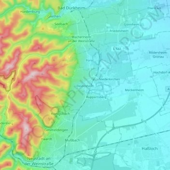
Nom : Carte topographique Deidesheim, altitude, relief.
Altitude moyenne : 194 m
Altitude minimum : 98 m
Altitude maximum : 544 m
Faire un don
Équipez-vous pour votre prochaine aventure :
En tant que Partenaire Amazon, ce site perçoit une commission sur les achats éligibles sans surcoût pour vous.
Autres cartes topographiques
Cliquez sur une carte pour visualiser sa topographie, son altitude et son relief.