
Faire un don
Équipez-vous pour votre prochaine aventure :
En tant que Partenaire Amazon, ce site perçoit une commission sur les achats éligibles sans surcoût pour vous.
Carte topographique Gadahinglaj
Cliquez sur la carte pour afficher l’altitude.
Faire un don
Équipez-vous pour votre prochaine aventure :
En tant que Partenaire Amazon, ce site perçoit une commission sur les achats éligibles sans surcoût pour vous.
Gadahinglaj
Gadhinglaj is situated on the banks of the Hiranyakeshi river, which originates in the Amboli Ghats mountains. It is located at the border between Maharashtra and Karnataka. Maharashtra State Highway 134 passes through the city. Gadinglaj is the headquarters of South Kolhapur and a sub-district of the Kolhapur District. It is the largest city in South Kolhapur and has enough area and population to be deemed a district. The city is at an average elevation of 623 metres (2,044 ft).
Faire un don
Équipez-vous pour votre prochaine aventure :
En tant que Partenaire Amazon, ce site perçoit une commission sur les achats éligibles sans surcoût pour vous.
À propos de cette carte
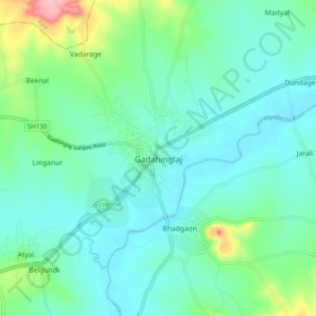
Nom : Carte topographique Gadahinglaj, altitude, relief.
Lieu : Gadahinglaj, Gadhinglaj, Kolhapur, Maharashtra, 416502, India (16.18369 74.31159 16.26369 74.39159)
Altitude moyenne : 655 m
Altitude minimum : 624 m
Altitude maximum : 773 m
Faire un don
Équipez-vous pour votre prochaine aventure :
En tant que Partenaire Amazon, ce site perçoit une commission sur les achats éligibles sans surcoût pour vous.
Autres cartes topographiques
Cliquez sur une carte pour visualiser sa topographie, son altitude et son relief.