
Faire un don
Équipez-vous pour votre prochaine aventure :
En tant que Partenaire Amazon, ce site perçoit une commission sur les achats éligibles sans surcoût pour vous.
Carte topographique Pinnacle Mountain
Cliquez sur la carte pour afficher l’altitude.
Faire un don
Équipez-vous pour votre prochaine aventure :
En tant que Partenaire Amazon, ce site perçoit une commission sur les achats éligibles sans surcoût pour vous.
À propos de cette carte
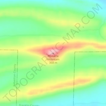
Nom : Carte topographique Pinnacle Mountain, altitude, relief.
Lieu : Pinnacle Mountain, Franklin County, Arkansas, United States (35.21365 -94.05331 35.21375 -94.05321)
Altitude moyenne : 253 m
Altitude minimum : 183 m
Altitude maximum : 364 m
Faire un don
Équipez-vous pour votre prochaine aventure :
En tant que Partenaire Amazon, ce site perçoit une commission sur les achats éligibles sans surcoût pour vous.
Autres cartes topographiques
Cliquez sur une carte pour visualiser sa topographie, son altitude et son relief.
Altus
United States > Arkansas > Franklin County > Altus
Altus had its start in 1875 when the railroad was extended to that point. Altus station was the highest point on the track. In recognition of this highest railroad elevation between Little Rock and Fort Smith, the station was originally known as "Summit". The town's initial development was due to railroad…
Altitude moyenne : 192 m