
Carte topographique East Sussex
Carte interactive
Cliquez sur la carte pour afficher l’altitude.
À propos de cette carte
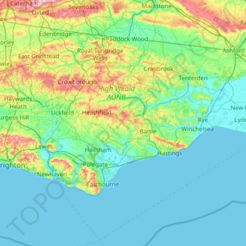
Nom : Carte topographique East Sussex, altitude, relief.
Lieu : East Sussex, England, United Kingdom (50.73343 -0.24508 51.14746 0.86786)
Altitude moyenne : 44 m
Altitude minimum : -2 m
Altitude maximum : 270 m
The chalk uplands of the South Downs occupies the coastal strip between Brighton and Eastbourne. There are two river gaps: the Rivers Ouse and Cuckmere. The Seven Sisters, where the Downs meet the sea, are the remnants of dry valleys cut into the chalk; they end at Beachy Head, 530 feet (162 m) above sea level. To the east of Beachy Head lie the marshlands of the Pevensey Levels, formerly flooded by the sea but now enclosed within a deposited beach. At Bexhill the land begins to rise again where the sands and clays of the Weald meet the sea; these culminate in the sandstone cliffs east of Hastings. Further east are the Pett Levels, more marshland, beyond which is the estuary of the River Rother. On the far side of the estuary are the dunes of Camber Sands. The highest point in the county is Ditchling Beacon on the South Downs, which has a maximum elevation of 248 m (814 ft) and is classed as a Marilyn.
Autres cartes topographiques
Cliquez sur une carte pour visualiser sa topographie, son altitude et son relief.
Wadhurst
United Kingdom > England > East Sussex > Wealden
Wadhurst, Wealden, East Sussex, England, United Kingdom
Altitude moyenne : 109 m
Frant
United Kingdom > England > East Sussex > Wealden > Bells Yew Green
Frant, Bells Yew Green, Wealden, East Sussex, England, United Kingdom
Altitude moyenne : 111 m
Ticehurst
United Kingdom > England > East Sussex > Rother
Ticehurst, Rother, East Sussex, England, United Kingdom
Altitude moyenne : 81 m
Brighton
United Kingdom > England > East Sussex
Brighton, East Sussex, England, BN1 1HH, United Kingdom
Altitude moyenne : 28 m
Bexhill-on-Sea
United Kingdom > England > East Sussex > Rother
Bexhill-on-Sea, Rother, East Sussex, England, TN39 3PE, United Kingdom
Altitude moyenne : 13 m
Lewes Castle
United Kingdom > England > East Sussex > Lewes
Lewes Castle, Castle Lane, Southover, Lewes, East Sussex, England, BN7 1YU, United Kingdom
Altitude moyenne : 26 m
Heathfield
United Kingdom > England > East Sussex > Wealden
Heathfield, Wealden, East Sussex, England, TN21 8PJ, United Kingdom
Altitude moyenne : 99 m
Blackboys
United Kingdom > England > East Sussex > Wealden
Blackboys, Wealden, East Sussex, England, TN22 5LF, United Kingdom
Altitude moyenne : 71 m
Maple
United Kingdom > England > East Sussex > Lewes > Offham
Maple, Nevill Road, Wallands Park, Lewes, Offham, Lewes, East Sussex, England, BN7 1PD, United Kingdom
Altitude moyenne : 45 m
Hailsham
United Kingdom > England > East Sussex > Wealden > Hailsham
Hailsham, Wealden, East Sussex, England, United Kingdom
Altitude moyenne : 14 m
St Leonards
United Kingdom > England > East Sussex
St Leonards, Hastings, East Sussex, England, TN38 0NY, United Kingdom
Altitude moyenne : 31 m
Battle
United Kingdom > England > East Sussex > Rother > Battle
Battle, Rother, East Sussex, South East England, England, United Kingdom
Altitude moyenne : 66 m
Burwash
United Kingdom > England > East Sussex > Rother
Burwash, Rother, East Sussex, England, TN19 7EP, United Kingdom
Altitude moyenne : 56 m
Rother
United Kingdom > England > East Sussex
Rother, East Sussex, England, United Kingdom
Altitude moyenne : 36 m
Lewes
United Kingdom > England > East Sussex
Lewes, East Sussex, England, United Kingdom
Altitude moyenne : 40 m
Wealden
United Kingdom > England > East Sussex
Wealden, East Sussex, England, United Kingdom
Altitude moyenne : 61 m
Hastings
United Kingdom > England > East Sussex
Hastings, East Sussex, England, United Kingdom
Altitude moyenne : 36 m