
Faire un don
Équipez-vous pour votre prochaine aventure :
En tant que Partenaire Amazon, ce site perçoit une commission sur les achats éligibles sans surcoût pour vous.
Carte topographique Nagaur
Cliquez sur la carte pour afficher l’altitude.
Faire un don
Équipez-vous pour votre prochaine aventure :
En tant que Partenaire Amazon, ce site perçoit une commission sur les achats éligibles sans surcoût pour vous.
Nagaur
Nagaur is located at 27°12′N 73°44′E / 27.2°N 73.73°E / 27.2; 73.73. It has an average elevation of 302 metres (990 feet). Nagaur is situated amidst seven districts namely Bikaner, Churu, Sikar, Jaipur, Ajmer, Pali, Jodhpur. Nagaur is the fifth largest district in Rajasthan with a vast terrain spreading over 17,718 km2 (6,841 sq mi) Its geographical spread is a good combine of plain, hills, sand mounds and as such it is a part of the great Indian Thar Desert.
Faire un don
Équipez-vous pour votre prochaine aventure :
En tant que Partenaire Amazon, ce site perçoit une commission sur les achats éligibles sans surcoût pour vous.
À propos de cette carte
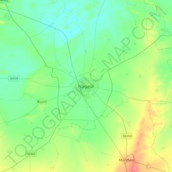
Nom : Carte topographique Nagaur, altitude, relief.
Altitude moyenne : 303 m
Altitude minimum : 278 m
Altitude maximum : 376 m
Faire un don
Équipez-vous pour votre prochaine aventure :
En tant que Partenaire Amazon, ce site perçoit une commission sur les achats éligibles sans surcoût pour vous.