
Faire un don
Équipez-vous pour votre prochaine aventure :
En tant que Partenaire Amazon, ce site perçoit une commission sur les achats éligibles sans surcoût pour vous.
Carte topographique Nationalpark Harz
Cliquez sur la carte pour afficher l’altitude.
Faire un don
Équipez-vous pour votre prochaine aventure :
En tant que Partenaire Amazon, ce site perçoit une commission sur les achats éligibles sans surcoût pour vous.
Nationalpark Harz
Several rivers have their sources in the national park, including the Bode, the Oder and the Ilse, a tributary of the Oker. The waters of the Oder, flowing southwards, are collected in the historic Oderteich reservoir, finished in 1722 to supply the mines in Sankt Andreasberg, and feed the Oder Dam on the southeastern edge of the park. Other dams and lakes within or bordering on the national park include the Ecker Dam and the Silberteich. The highest elevations are the Brocken, the Bruchberg and the Achtermann.
Faire un don
Équipez-vous pour votre prochaine aventure :
En tant que Partenaire Amazon, ce site perçoit une commission sur les achats éligibles sans surcoût pour vous.
À propos de cette carte
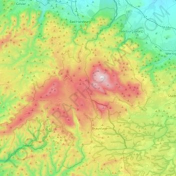
Nom : Carte topographique Nationalpark Harz, altitude, relief.
Lieu : Nationalpark Harz, Landkreis Goslar, Lower Saxony, Germany (51.66833 10.31921 51.90061 10.72798)
Altitude moyenne : 533 m
Altitude minimum : 167 m
Altitude maximum : 1.139 m
Faire un don
Équipez-vous pour votre prochaine aventure :
En tant que Partenaire Amazon, ce site perçoit une commission sur les achats éligibles sans surcoût pour vous.
Autres cartes topographiques
Cliquez sur une carte pour visualiser sa topographie, son altitude et son relief.