
Carte topographique Erattupetta
Cliquez sur la carte pour afficher l’altitude.
Erattupetta
Erattupetta can be easily accessed from north Kerala via the Angamaly-Muvattupuzha-Thodupuzha-Muttom route. It is also well connected to Tamil Nadu via the Kottayam-Kumali Road(KK Road) to Madurai, through the nearest town, Mundakkayam, via Parathanam, which is 27 kilometers from Erattupetta. The town has an average elevation of 36 meters (118 feet).
À propos de cette carte
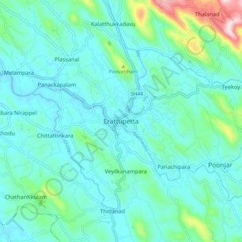
Nom : Carte topographique Erattupetta, altitude, relief.
Lieu : Erattupetta, Meenachil, Kottayam, Kerala, 686122, India (9.64799 76.73977 9.72799 76.81977)
Altitude moyenne : 78 m
Altitude minimum : 10 m
Altitude maximum : 415 m
Autres cartes topographiques
Cliquez sur une carte pour visualiser sa topographie, son altitude et son relief.
Cherppungal Kulam Cheripurathu Padasekaram Karikombu
India > Kerala > Meenachil > Cherpunkal
Altitude moyenne : 29 m