
Carte topographique Franklin
Carte interactive
Cliquez sur la carte pour afficher l’altitude.
Franklin
According to the United States Census Bureau, the city has a total area of 29.2 square miles (75.5 km2), of which 27.5 square miles (71.1 km2) are land and 1.7 square miles (4.5 km2) are water, comprising 5.95% of the town. It is drained by the Winnipesaukee, Pemigewasset and Merrimack rivers. Webster Lake is in the north. The highest point in Franklin is an unnamed summit near the northwestern corner of the city limits, where the elevation reaches approximately 1,370 feet (420 m) above sea level. Franklin lies fully within the Merrimack River watershed.
À propos de cette carte
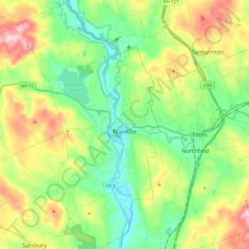
Nom : Carte topographique Franklin, altitude, relief.
Altitude moyenne : 201 m
Altitude minimum : 76 m
Altitude maximum : 431 m
Autres cartes topographiques
Cliquez sur une carte pour visualiser sa topographie, son altitude et son relief.
Rings Corner
United States > New Hampshire > Merrimack County > Pittsfield > Rings Corner
Altitude moyenne : 190 m