
Faire un don
Équipez-vous pour votre prochaine aventure :
En tant que Partenaire Amazon, ce site perçoit une commission sur les achats éligibles sans surcoût pour vous.
Carte topographique Hudson River
Cliquez sur la carte pour afficher l’altitude.
Faire un don
Équipez-vous pour votre prochaine aventure :
En tant que Partenaire Amazon, ce site perçoit une commission sur les achats éligibles sans surcoût pour vous.
Hudson River
The source of the Hudson River is Lake Tear of the Clouds in the Adirondack Park at an elevation of 4,322 feet (1,317 m). However, the river is not cartographically called the Hudson River until miles downstream. The river is named Feldspar Brook until its confluence with the Opalescent River, and then is named the Opalescent River until the river reaches Calamity Brook, flowing south from the outlet of Henderson Lake. From that point on, the stream is cartographically known as the Hudson River. The U.S. Geological Survey (USGS) uses this cartographical definition.
Faire un don
Équipez-vous pour votre prochaine aventure :
En tant que Partenaire Amazon, ce site perçoit une commission sur les achats éligibles sans surcoût pour vous.
À propos de cette carte
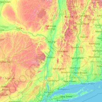
Nom : Carte topographique Hudson River, altitude, relief.
Lieu : Hudson River, New York, United States (40.69994 -74.19885 44.09098 -73.57319)
Altitude moyenne : 301 m
Altitude minimum : -2 m
Altitude maximum : 1.384 m
Faire un don
Équipez-vous pour votre prochaine aventure :
En tant que Partenaire Amazon, ce site perçoit une commission sur les achats éligibles sans surcoût pour vous.
Autres cartes topographiques
Cliquez sur une carte pour visualiser sa topographie, son altitude et son relief.
Central Park
United States > New York > New York County > New York
In June 1856, Fernando Wood appointed a "consulting board" of seven people, headed by author Washington Irving, to inspire public confidence in the proposed development. Wood hired military engineer Egbert Ludovicus Viele as the park's chief engineer, tasking him with a topographical survey of the site. The…
Altitude moyenne : 26 m
Mariandale
United States > New York > Westchester County > Village of Ossining
Altitude moyenne : 53 m
Faire un don
Équipez-vous pour votre prochaine aventure :
En tant que Partenaire Amazon, ce site perçoit une commission sur les achats éligibles sans surcoût pour vous.
Central Park
United States > New York > New York County > New York
In June 1856, Fernando Wood appointed a "consulting board" of seven people, headed by author Washington Irving, to inspire public confidence in the proposed development. Wood hired military engineer Egbert Ludovicus Viele as the park's chief engineer, tasking him with a topographical survey of the site. The…
Altitude moyenne : 26 m
Tug Hill
United States > New York > Oswego County
The core Tug Hill region encompasses 150,000 acres (610 km2) of unbroken, generally second-growth, northern hardwood forest, and is drained by a vast network of streams. Important rivers and streams whose headwaters are located within the Tug Hill region include the Mohawk River, Deer River, Salmon River, Mad…
Altitude moyenne : 109 m
Riverside Park
United States > New York > New York County > New York
Initially, Riverside Avenue had been planned to run in a straight line, which would have required a retaining wall and extensive fill. However, the area's difficult topography had come to the attention of the Manhattan park commissioners. In 1873, the commissioners selected Frederick Law Olmsted, a park…
Altitude moyenne : 17 m
Faire un don
Équipez-vous pour votre prochaine aventure :
En tant que Partenaire Amazon, ce site perçoit une commission sur les achats éligibles sans surcoût pour vous.
Mount Marcy
United States > New York > Essex County > Town of Keene
Mount Marcy is the highest point in the Adirondack Mountains and the U.S. state of New York, with an elevation of 5,343.1 feet (1,628.6 m). It is located in the town of Keene in Essex County. The mountain is in the heart of the High Peaks Wilderness Area in Adirondack Park. Like the surrounding Adirondack…
Altitude moyenne : 1.289 m
Faire un don
Équipez-vous pour votre prochaine aventure :
En tant que Partenaire Amazon, ce site perçoit une commission sur les achats éligibles sans surcoût pour vous.
Whitesville
United States > New York > Allegany County > Town of Independence
Altitude moyenne : 611 m
Faire un don
Équipez-vous pour votre prochaine aventure :
En tant que Partenaire Amazon, ce site perçoit une commission sur les achats éligibles sans surcoût pour vous.
Hartmans Corners
United States > New York > Albany County > Town of Guilderland
Altitude moyenne : 81 m
Faire un don
Équipez-vous pour votre prochaine aventure :
En tant que Partenaire Amazon, ce site perçoit une commission sur les achats éligibles sans surcoût pour vous.
Faire un don
Équipez-vous pour votre prochaine aventure :
En tant que Partenaire Amazon, ce site perçoit une commission sur les achats éligibles sans surcoût pour vous.
Pleasantside
United States > New York > Westchester County > Town of Cortlandt
Altitude moyenne : 108 m
Faire un don
Équipez-vous pour votre prochaine aventure :
En tant que Partenaire Amazon, ce site perçoit une commission sur les achats éligibles sans surcoût pour vous.
Faire un don
Équipez-vous pour votre prochaine aventure :
En tant que Partenaire Amazon, ce site perçoit une commission sur les achats éligibles sans surcoût pour vous.
Faire un don
Équipez-vous pour votre prochaine aventure :
En tant que Partenaire Amazon, ce site perçoit une commission sur les achats éligibles sans surcoût pour vous.
Inwood Hill Park
United States > New York > New York County > New York
Inwood Hill Park is a 196 acres (79 ha) public park in the Inwood neighborhood of Manhattan, New York City, operated by the New York City Department of Parks and Recreation. On a high schist ridge that rises 200 feet (61 m) above the Hudson River from Dyckman Street to the northern tip of the island, Inwood…
Altitude moyenne : 14 m
Faire un don
Équipez-vous pour votre prochaine aventure :
En tant que Partenaire Amazon, ce site perçoit une commission sur les achats éligibles sans surcoût pour vous.
Brooklyn Bridge Park
United States > New York > Kings County > New York
Brooklyn Bridge Park spans 85 acres (34 ha) of the East River waterfront in the Brooklyn Heights and Dumbo neighborhoods of Brooklyn. The park is divided into eleven sections: Piers 1 through 6; Fulton Ferry Landing; Brooklyn Bridge Plaza; Empire Fulton Ferry; Main Street; and John Street. Each of these…
Altitude moyenne : 9 m
Catamount Mountain
United States > New York > Saint Lawrence County > Town of Colton
Altitude moyenne : 433 m
Faire un don
Équipez-vous pour votre prochaine aventure :
En tant que Partenaire Amazon, ce site perçoit une commission sur les achats éligibles sans surcoût pour vous.
Oscawana Corners
United States > New York > Putnam County > Town of Putnam Valley
Altitude moyenne : 158 m
Faire un don
Équipez-vous pour votre prochaine aventure :
En tant que Partenaire Amazon, ce site perçoit une commission sur les achats éligibles sans surcoût pour vous.
Faire un don
Équipez-vous pour votre prochaine aventure :
En tant que Partenaire Amazon, ce site perçoit une commission sur les achats éligibles sans surcoût pour vous.
Faire un don
Équipez-vous pour votre prochaine aventure :
En tant que Partenaire Amazon, ce site perçoit une commission sur les achats éligibles sans surcoût pour vous.
Woodcock Mountain
United States > New York > Saratoga County > Town of Hadley
Altitude moyenne : 271 m
Constantia Center
United States > New York > Oswego County > Town of Constantia
Altitude moyenne : 169 m
South New Berlin
United States > New York > Chenango County > Town of New Berlin
Altitude moyenne : 380 m
Faire un don
Équipez-vous pour votre prochaine aventure :
En tant que Partenaire Amazon, ce site perçoit une commission sur les achats éligibles sans surcoût pour vous.
Faire un don
Équipez-vous pour votre prochaine aventure :
En tant que Partenaire Amazon, ce site perçoit une commission sur les achats éligibles sans surcoût pour vous.
Coney Island
United States > New York > Saint Lawrence County > Town of Pierrepont
Altitude moyenne : 174 m
Faire un don
Équipez-vous pour votre prochaine aventure :
En tant que Partenaire Amazon, ce site perçoit une commission sur les achats éligibles sans surcoût pour vous.
Faire un don
Équipez-vous pour votre prochaine aventure :
En tant que Partenaire Amazon, ce site perçoit une commission sur les achats éligibles sans surcoût pour vous.
Faire un don
Équipez-vous pour votre prochaine aventure :
En tant que Partenaire Amazon, ce site perçoit une commission sur les achats éligibles sans surcoût pour vous.
Faire un don
Équipez-vous pour votre prochaine aventure :
En tant que Partenaire Amazon, ce site perçoit une commission sur les achats éligibles sans surcoût pour vous.
Sunset Ridge
United States > New York > Westchester County > Town/Village of Harrison
Altitude moyenne : 27 m
Faire un don
Équipez-vous pour votre prochaine aventure :
En tant que Partenaire Amazon, ce site perçoit une commission sur les achats éligibles sans surcoût pour vous.
Ellicottville
United States > New York > Cattaraugus County > Village of Ellicottville
Altitude moyenne : 573 m
Faire un don
Équipez-vous pour votre prochaine aventure :
En tant que Partenaire Amazon, ce site perçoit une commission sur les achats éligibles sans surcoût pour vous.
Faire un don
Équipez-vous pour votre prochaine aventure :
En tant que Partenaire Amazon, ce site perçoit une commission sur les achats éligibles sans surcoût pour vous.
East Poestenkill
United States > New York > Rensselaer County > Town of Poestenkill
Altitude moyenne : 376 m
Faire un don
Équipez-vous pour votre prochaine aventure :
En tant que Partenaire Amazon, ce site perçoit une commission sur les achats éligibles sans surcoût pour vous.
Faire un don
Équipez-vous pour votre prochaine aventure :
En tant que Partenaire Amazon, ce site perçoit une commission sur les achats éligibles sans surcoût pour vous.