
Faire un don
Équipez-vous pour votre prochaine aventure :
En tant que Partenaire Amazon, ce site perçoit une commission sur les achats éligibles sans surcoût pour vous.
Carte topographique Stratford
Cliquez sur la carte pour afficher l’altitude.
Faire un don
Équipez-vous pour votre prochaine aventure :
En tant que Partenaire Amazon, ce site perçoit une commission sur les achats éligibles sans surcoût pour vous.
Stratford
According to the United States Census Bureau, the town has a total area of 19.9 square miles (52 km2), of which 17.6 square miles (46 km2) is land and 2.3 square miles (6.0 km2), or 11.52%, is water. Stratford has a minimum elevation of zero feet above sea level along its coastline, with a maximum altitude of 295 feet (90 m) near its northern border, and an average elevation of 23 feet (7.0 m).
Faire un don
Équipez-vous pour votre prochaine aventure :
En tant que Partenaire Amazon, ce site perçoit une commission sur les achats éligibles sans surcoût pour vous.
À propos de cette carte
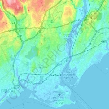
Nom : Carte topographique Stratford, altitude, relief.
Altitude moyenne : 25 m
Altitude minimum : -8 m
Altitude maximum : 149 m
Faire un don
Équipez-vous pour votre prochaine aventure :
En tant que Partenaire Amazon, ce site perçoit une commission sur les achats éligibles sans surcoût pour vous.
Autres cartes topographiques
Cliquez sur une carte pour visualiser sa topographie, son altitude et son relief.
Oronoque
United States > Connecticut > Greater Bridgeport Planning Region > Stratford
Altitude moyenne : 37 m
Southport
United States > Connecticut > Greater Bridgeport Planning Region > Fairfield
Altitude moyenne : 11 m
Long Hill
United States > Connecticut > Greater Bridgeport Planning Region > Trumbull
Altitude moyenne : 117 m
Barn Hill
United States > Connecticut > Greater Bridgeport Planning Region > Monroe
Altitude moyenne : 146 m
Faire un don
Équipez-vous pour votre prochaine aventure :
En tant que Partenaire Amazon, ce site perçoit une commission sur les achats éligibles sans surcoût pour vous.
Long Hill
United States > Connecticut > Greater Bridgeport Planning Region > Trumbull
Altitude moyenne : 117 m
Powells Hill
United States > Connecticut > Greater Bridgeport Planning Region > Easton
Altitude moyenne : 87 m
Stratfield
United States > Connecticut > Greater Bridgeport Planning Region > Fairfield
Altitude moyenne : 53 m
Lordship Beach
United States > Connecticut > Greater Bridgeport Planning Region > Stratford > Lordship
Altitude moyenne : 1 m
Faire un don
Équipez-vous pour votre prochaine aventure :
En tant que Partenaire Amazon, ce site perçoit une commission sur les achats éligibles sans surcoût pour vous.