
Carte topographique Cottonwood County
Carte interactive
Cliquez sur la carte pour afficher l’altitude.
À propos de cette carte
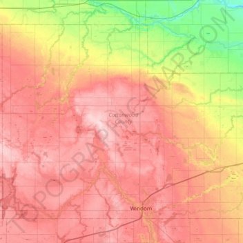
Nom : Carte topographique Cottonwood County, altitude, relief.
Lieu : Cottonwood County, Minnesota, United States of America (43.84964 -95.46328 44.19704 -94.85834)
Altitude moyenne : 401 m
Altitude minimum : 304 m
Altitude maximum : 496 m
Autres cartes topographiques
Cliquez sur une carte pour visualiser sa topographie, son altitude et son relief.
Cohasset
United States of America > Minnesota > Cohasset
Cohasset, Itasca County, Minnesota, 55721, United States of America
Altitude moyenne : 395 m
Lismore
United States of America > Minnesota > Lismore
Lismore, Nobles County, Minnesota, United States of America
Altitude moyenne : 510 m
Brownton
United States of America > Minnesota > Brownton
Brownton, McLeod County, Minnesota, United States of America
Altitude moyenne : 314 m
Farmington
United States of America > Minnesota > Farmington
Farmington, Dakota County, Minnesota, 55024, United States of America
Altitude moyenne : 280 m
Twin Lakes
United States of America > Minnesota > Twin Lakes
Twin Lakes, Freeborn County, Minnesota, 56089, United States of America
Altitude moyenne : 384 m
Clearwater County
United States of America > Minnesota
Clearwater County, Minnesota, United States of America
Altitude moyenne : 409 m
Hilltop
United States of America > Minnesota > Hilltop > Hilltop
Hilltop, Anoka County, Minnesota, 55421, United States of America
Altitude moyenne : 273 m
Stevens County
United States of America > Minnesota
Stevens County, Minnesota, United States of America
Altitude moyenne : 345 m
Round Lake
United States of America > Minnesota > Round Lake
Round Lake, Nobles County, Minnesota, 56167, United States of America
Altitude moyenne : 472 m
Spring Valley
United States of America > Minnesota > Spring Valley
Spring Valley, Fillmore County, Minnesota, United States of America
Altitude moyenne : 400 m
Beltrami County
United States of America > Minnesota
Beltrami County, Minnesota, United States of America
Altitude moyenne : 386 m
Wilkin County
United States of America > Minnesota
Wilkin County, Minnesota, United States of America
Altitude moyenne : 320 m
Bemidji
United States of America > Minnesota > Bemidji
Bemidji, Beltrami County, Minnesota, 56601, United States of America
Altitude moyenne : 417 m
Hennepin County
United States of America > Minnesota
Hennepin County, Minnesota, United States of America
Altitude moyenne : 280 m