
Carte topographique Haingrün
Carte interactive
Cliquez sur la carte pour afficher l’altitude.
À propos de cette carte
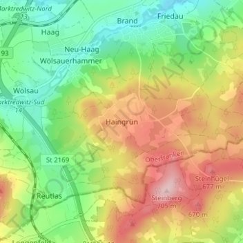
Nom : Carte topographique Haingrün, altitude, relief.
Altitude moyenne : 574 m
Altitude minimum : 483 m
Altitude maximum : 693 m
Autres cartes topographiques
Cliquez sur une carte pour visualiser sa topographie, son altitude et son relief.
Brand
Deutschland > Bayern > Landkreis Wunsiedel im Fichtelgebirge > Marktredwitz
Brand, Marktredwitz, Landkreis Wunsiedel im Fichtelgebirge, Bayern, Deutschland
Altitude moyenne : 536 m
Ziegelhütte
Deutschland > Bayern > Landkreis Wunsiedel im Fichtelgebirge > Marktredwitz
Ziegelhütte, Marktredwitz, Landkreis Wunsiedel im Fichtelgebirge, Bayern, 95679, Deutschland
Altitude moyenne : 563 m