
Faire un don
Équipez-vous pour votre prochaine aventure :
En tant que Partenaire Amazon, ce site perçoit une commission sur les achats éligibles sans surcoût pour vous.
Carte topographique Little Grand Canyon
Cliquez sur la carte pour afficher l’altitude.
Faire un don
Équipez-vous pour votre prochaine aventure :
En tant que Partenaire Amazon, ce site perçoit une commission sur les achats éligibles sans surcoût pour vous.
Little Grand Canyon
Erosion carved this deep box canyon from the sandstone of the Shawnee Hills, opening into the floodplain of the Mississippi River near Turkey Bayou. The canyon contains several seasonal and a few permanent waterfalls, some descending through dramatic cascades of sculpted sandstone. The 3.6-mile (5.8 km) trail is marked by white diamond blazes and begins in the upland hardwood forest. The trail then descends through a steep and sometimes slippery sandstone side canyon to the lusher, damper habitat of the canyon floor. The ascent from the canyon requires a small amount of climbing at the Three Sisters Waterfall. Stone steps on parts of the trail were constructed by the Civilian Conservation Corps, not by Native Americans as some believe. There is an approximate 350-foot (110 m) difference in elevation between the bottom of the canyon and the trailhead. The trailhead facilities include a picnic area and pit toilet. No water is available. Hikers should be aware of unmarked and unguarded cliff edges and the possibility of flash floods during heavy rain.
Faire un don
Équipez-vous pour votre prochaine aventure :
En tant que Partenaire Amazon, ce site perçoit une commission sur les achats éligibles sans surcoût pour vous.
À propos de cette carte
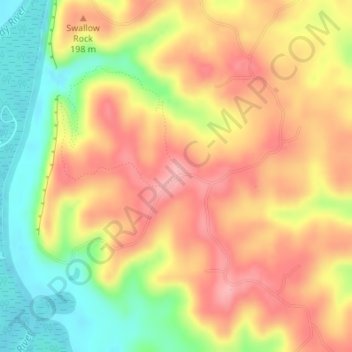
Nom : Carte topographique Little Grand Canyon, altitude, relief.
Lieu : Little Grand Canyon, Jackson County, Illinois, United States (37.68048 -89.39550 37.68058 -89.39540)
Altitude moyenne : 168 m
Altitude minimum : 100 m
Altitude maximum : 221 m
Faire un don
Équipez-vous pour votre prochaine aventure :
En tant que Partenaire Amazon, ce site perçoit une commission sur les achats éligibles sans surcoût pour vous.
Autres cartes topographiques
Cliquez sur une carte pour visualiser sa topographie, son altitude et son relief.
Faire un don
Équipez-vous pour votre prochaine aventure :
En tant que Partenaire Amazon, ce site perçoit une commission sur les achats éligibles sans surcoût pour vous.
Faire un don
Équipez-vous pour votre prochaine aventure :
En tant que Partenaire Amazon, ce site perçoit une commission sur les achats éligibles sans surcoût pour vous.