
Faire un don
Équipez-vous pour votre prochaine aventure :
En tant que Partenaire Amazon, ce site perçoit une commission sur les achats éligibles sans surcoût pour vous.
Carte topographique Cabudare
Cliquez sur la carte pour afficher l’altitude.
Faire un don
Équipez-vous pour votre prochaine aventure :
En tant que Partenaire Amazon, ce site perçoit une commission sur les achats éligibles sans surcoût pour vous.
Cabudare
Cabudare (Spanish pronunciation: [kaβuˈðaɾe], original indigenous name Kabudari), is a city in Lara State, in Venezuela, and capital of the Palavecino Municipality. Located at an elevation of 400 m on the Turbio River, it is on the major west-central freeway, the Autopista Centro Occidental. Due to the growth of the economy in Barquisimeto, Cabudare has become a bedroom community, with new housing construction replacing the sugar cane fields. A minority of the population are still engaged in agriculture within the municipality.
Faire un don
Équipez-vous pour votre prochaine aventure :
En tant que Partenaire Amazon, ce site perçoit une commission sur les achats éligibles sans surcoût pour vous.
À propos de cette carte
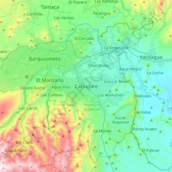
Nom : Carte topographique Cabudare, altitude, relief.
Altitude moyenne : 637 m
Altitude minimum : 282 m
Altitude maximum : 1.730 m
Faire un don
Équipez-vous pour votre prochaine aventure :
En tant que Partenaire Amazon, ce site perçoit une commission sur les achats éligibles sans surcoût pour vous.