
Carte topographique Taos County
Carte interactive
Cliquez sur la carte pour afficher l’altitude.
Carte topographique Taos County, altitude, relief
Taos County
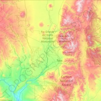
The county's highest point is the summit of Wheeler Peak at 13,161 feet (4,011 m). This is also the highest natural point in New Mexico. The county has the highest mean elevation of any U.S. county outside of Colorado at 8,510 feet (2,590 m), even though it ranks only 22nd overall. Taos County contains 17 of New Mexico's highest 25 peaks.
À propos de cette carte
Nom : Carte topographique Taos County, altitude, relief.
Lieu : Taos County, New Mexico, United States of America (36.01287 -106.05840 36.99597 -105.20011)
Altitude moyenne : 2.561 m
Altitude minimum : 1.709 m
Altitude maximum : 3.980 m
Autres cartes topographiques
Cliquez sur une carte pour visualiser sa topographie, son altitude et son relief.