
Carte topographique Leyte
Carte interactive
Cliquez sur la carte pour afficher l’altitude.
À propos de cette carte
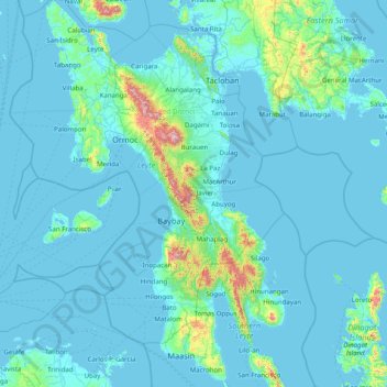
Nom : Carte topographique Leyte, altitude, relief.
Lieu : Leyte, Eastern Visayas, Philippines (10.00448 124.28589 11.56351 125.26800)
Altitude moyenne : 68 m
Altitude minimum : -1 m
Altitude maximum : 1.238 m
Mahagnao Volcano Natural Park Located in Burauen, Leyte, about 66 km (41 mi) from Tacloban City, the Mahagnao Volcano Natural Park attracts visitors with its lakes, craters, hot springs, multi-colored mud, virgin forests and lagoon. It was proclaimed as a national park in 1937. Like other regions in the Philippines, the area enjoys a temperate climate. It has an elevation of 1,200 meters above sea level and an area of 635 hectares, within the boundaries of Burauen, La Paz and McArthur towns.
Autres cartes topographiques
Cliquez sur une carte pour visualiser sa topographie, son altitude et son relief.
Cuta
Philippines > Leyte > Barugo
Cuta, Barugo, 2nd District, Leyte, Eastern Visayas, 6519, Philippines
Altitude moyenne : 7 m
Mount Magsanga
Philippines > Leyte > Merida
Mount Magsanga, Merida, 4th District, Leyte, Eastern Visayas, 6540, Philippines
Altitude moyenne : 286 m
Green Valley
Philippines > Leyte > Ormoc
Green Valley, Ormoc, 4th District, Leyte, Eastern Visayas, 6541, Philippines
Altitude moyenne : 81 m
Patag
Philippines > Leyte > Baybay
Patag, Baybay, 5th District, Leyte, Eastern Visayas, 6521, Philippines
Altitude moyenne : 64 m
Paglaum
Philippines > Leyte > Carigara
Paglaum, Carigara, Leyte 2nd District, Leyte, Eastern Visayas, 6529, Philippines
Altitude moyenne : 276 m
Matag-Ob
Matag-Ob, Leyte 4th District, Leyte, Eastern Visayas, 6532, Philippines
Altitude moyenne : 66 m
Paglocsoon
Philippines > Leyte > Ormoc > Dolores
Paglocsoon, Dolores, Ormoc, Leyte 4th District, Leyte, Eastern Visayas, 6541, Philippines
Altitude moyenne : 322 m
Barugo
Barugo, Leyte 2nd District, Leyte, Eastern Visayas, 6519, Philippines
Altitude moyenne : 12 m
Hilongos
Hilongos, Leyte 5th District, Leyte, Eastern Visayas, 6524, Philippines
Altitude moyenne : 113 m
Imelda
Philippines > Leyte > Hilongos
Imelda, Hilongos, Leyte 5th District, Leyte, Eastern Visayas, 6524, Philippines
Altitude moyenne : 49 m
Palompon
Palompon, Leyte 4th District, Leyte, Eastern Visayas, 6538, Philippines
Altitude moyenne : 31 m
Sto. Nino
Philippines > Leyte > Mahaplag
Sto. Nino, Mahaplag, Leyte 5th District, Leyte, Eastern Visayas, 6512, Philippines
Altitude moyenne : 174 m
Cabacungan
Philippines > Leyte > Dulag
Cabacungan, Dulag, Leyte 2nd District, Leyte, Eastern Visayas, 6505, Philippines
Altitude moyenne : 13 m
San Isidro
Philippines > Leyte > Jaro
San Isidro, Jaro, Leyte 2nd District, Leyte, Eastern Visayas, 6527, Philippines
Altitude moyenne : 57 m
Sea of Clouds
Philippines > Leyte > Baybay
Sea of Clouds, Abuyog-Baybay City South Road, Baybay, Leyte 5th District, Leyte, Eastern Visayas, 6521, Philippines
Altitude moyenne : 187 m
Matalom
Matalom, Leyte 5th District, Leyte, Eastern Visayas, 6526, Philippines
Altitude moyenne : 85 m
Inopacan
Inopacan, Leyte 5th District, Leyte, Eastern Visayas, 6522, Philippines
Altitude moyenne : 113 m
Uyawan
Philippines > Leyte > Carigara
Uyawan, Carigara, Leyte 2nd District, Leyte, Eastern Visayas, 6529, Philippines
Altitude moyenne : 11 m
Ormoc
Ormoc, Leyte 4th District, Leyte, Eastern Visayas, 6541, Philippines
Altitude moyenne : 210 m
Calubian
Philippines > Leyte > Calubian
Calubian, Leyte 3rd District, Leyte, Eastern Visayas, 6534, Philippines
Altitude moyenne : 148 m
Baybay
Baybay, Leyte 5th District, Leyte, Eastern Visayas, 6521, Philippines
Altitude moyenne : 157 m
Barangay 62
Philippines > Leyte > Tacloban > Barangay 62
Barangay 62, Tacloban, Leyte, Eastern Visayas, 6500, Philippines
Altitude moyenne : 12 m