
Carte topographique Laufen
Carte interactive
Cliquez sur la carte pour afficher l’altitude.
À propos de cette carte
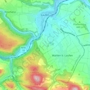
Nom : Carte topographique Laufen, altitude, relief.
Lieu : Laufen, Bezirk Laufen, Basel-Landschaft, 4242, Switzerland (47.38523 7.45617 47.42930 7.52310)
Altitude moyenne : 455 m
Altitude minimum : 347 m
Altitude maximum : 733 m
Autres cartes topographiques
Cliquez sur une carte pour visualiser sa topographie, son altitude et son relief.
Grellingen
Switzerland > Basel-Landschaft > Bezirk Laufen
Grellingen, Bezirk Laufen, Basel-Landschaft, 4203, Switzerland
Altitude moyenne : 479 m