Géolocaliser

Carte topographique Castletown

Cliquez sur la carte pour afficher l’altitude.

👉 Easily get elevation data in JSON, GeoTIFF and KML formats using Elevation API
Merci de soutenir ce site ❤️
Faire un don

À propos de cette carte

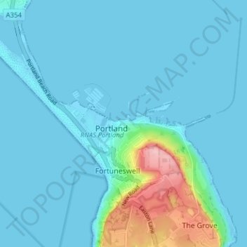
Nom : Carte topographique Castletown, altitude, relief.

Lieu : Castletown, Dorset, England, DT5 1BE, United Kingdom (50.54796 -2.46411 50.58796 -2.42411)

Altitude moyenne : 18 m

Altitude minimum : -5 m

Altitude maximum : 145 m

Autres cartes topographiques

Cliquez sur une carte pour visualiser sa topographie, son altitude et son relief.

Jurassic Coast

United Kingdom > England > Dorset > Bridport

Altitude moyenne : 49 m

Isle of Portland

United Kingdom > England > Dorset > Wyke Regis

In Museums Without Walls, Jonathan Meades declares that "Portland is a bulky chunk of geological, social, topographical and demographic weirdness. It is the obverse of a beauty spot. 'Beauty' in this construction implies the picturesque. Portland is gloriously bereft of this quality. It is awesome. There is…

Altitude moyenne : 11 m

Evershot

United Kingdom > England > Dorset

Altitude moyenne : 156 m

Frampton

United Kingdom > England > Dorset > Frampton

Altitude moyenne : 131 m

Ashmore

United Kingdom > England > Dorset

Altitude moyenne : 180 m

Ridge

United Kingdom > England > Dorset > Wareham > Ridge

Altitude moyenne : 7 m

Nether Compton

United Kingdom > England > Dorset

Altitude moyenne : 85 m

West Dorset

United Kingdom > England > Dorset

Altitude moyenne : 74 m

Toller Porcorum

United Kingdom > England > Dorset > Toller Porcorum

Altitude moyenne : 153 m

Wool

United Kingdom > England > Dorset > Bovington

Altitude moyenne : 37 m

Manston

United Kingdom > England > Dorset

Altitude moyenne : 51 m

Burning Cliff

United Kingdom > England > Dorset > South Holworth

Altitude moyenne : 64 m

Beaminster

United Kingdom > England > Dorset > Beaminster

Altitude moyenne : 136 m

Wimborne Minster

United Kingdom > England > Dorset

Altitude moyenne : 31 m

Chideock

United Kingdom > England > Dorset > Chideock

Altitude moyenne : 68 m

Corfe Castle

United Kingdom > England > Dorset

Altitude moyenne : 44 m

Cann

United Kingdom > England > Dorset

Altitude moyenne : 152 m

Bridport

United Kingdom > England > Dorset

Bridport is in the county of Dorset in South West England. Measured directly, it is about 14 miles (23 km) west of the county town Dorchester, 15.5 miles (25 km) SSW of Yeovil in Somerset, 33 miles (53 km) east of Exeter in Devon and 1.5 miles (2.4 km) inland from the English Channel at West Bay. The town…

Altitude moyenne : 32 m

Équipez-vous pour votre prochaine aventure :

🥾Chaussures Randonnée Homme - Bottes et chaussures imperméables pour sentiers techniques
🎒Sacs à Dos Randonnée - Sacs ergonomiques pour vos excursions d'une journée ou plus
📡Balises GPS de secours - Sécurité en zones isolées
🧥Vestes imperméables - Vestes coupe-vent et pluie pour outdoor
🚿Douches Solaires - Hygiène en pleine nature lors des treks

En tant que Partenaire Amazon, ce site perçoit une commission sur les achats éligibles sans surcoût pour vous.