
Carte topographique Ghaziabad
Carte interactive
Cliquez sur la carte pour afficher l’altitude.
À propos de cette carte
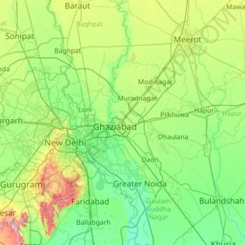
Nom : Carte topographique Ghaziabad, altitude, relief.
Lieu : Ghaziabad, Uttar Pradesh, Inde (28.43590 77.19924 28.93121 78.19876)
Altitude moyenne : 217 m
Altitude minimum : 186 m
Altitude maximum : 341 m
Autres cartes topographiques
Cliquez sur une carte pour visualiser sa topographie, son altitude et son relief.
Ait
Inde > Uttar Pradesh > Orai
Ait, Orai, Jalaun, Uttar Pradesh, 285201, Inde
Altitude moyenne : 154 m
Bareli
Inde > Uttar Pradesh > Bareilly
Bareli, Bareilly, Bareilly District, Uttar Pradesh, 243001, Inde
Altitude moyenne : 170 m
Ghaziabad
Inde > Uttar Pradesh > Ghaziabad District
Ghaziabad, Ghaziabad District, Uttar Pradesh, Inde
Altitude moyenne : 213 m
Beel Akbarpur
Inde > Uttar Pradesh > Beel Akbarpur
Beel Akbarpur, Ghaziabad, Uttar Pradesh, 201314, Inde
Altitude moyenne : 208 m