
Faire un don
Équipez-vous pour votre prochaine aventure :
En tant que Partenaire Amazon, ce site perçoit une commission sur les achats éligibles sans surcoût pour vous.
Carte topographique Thiruvalla
Cliquez sur la carte pour afficher l’altitude.
Faire un don
Équipez-vous pour votre prochaine aventure :
En tant que Partenaire Amazon, ce site perçoit une commission sur les achats éligibles sans surcoût pour vous.
Thiruvalla
Thiruvalla lies at an altitude of 9 meters above sea level on the basin of the Pamba and Manimala rivers. Thiruvalla is dotted with several natural canal streams (called "thodu" in Malayalam) like Chanthathodu, Manippuzha, Mullelithodu, and several others. The city area has riverine alluvial soil, and eastern parts have a laterite loam kind of soil classified under "Southern Midlands" agro-ecological zone, while the western suburbs like Niranam have a more sandy type of soil that resembles beaches. (Kuttanad agro-ecological zone)[7] The reason for this is believed to be the older status of Niranam as a port, before reclamation of Kuttanad from sea occurred. The Upper Kuttanad region in Thiruvalla has the "Karappadam" type of soil, which is clay loam in texture, has high organic matter, and is situated in areas about 1–2 m above sea level.[7]
Faire un don
Équipez-vous pour votre prochaine aventure :
En tant que Partenaire Amazon, ce site perçoit une commission sur les achats éligibles sans surcoût pour vous.
À propos de cette carte
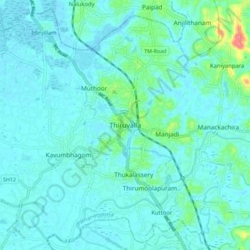
Nom : Carte topographique Thiruvalla, altitude, relief.
Lieu : Thiruvalla, Pathanamthitta, Kerala, 689111, India (9.34674 76.53627 9.42674 76.61627)
Altitude moyenne : 10 m
Altitude minimum : -1 m
Altitude maximum : 74 m
Faire un don
Équipez-vous pour votre prochaine aventure :
En tant que Partenaire Amazon, ce site perçoit une commission sur les achats éligibles sans surcoût pour vous.
Autres cartes topographiques
Cliquez sur une carte pour visualiser sa topographie, son altitude et son relief.