
Faire un don
Équipez-vous pour votre prochaine aventure :
En tant que Partenaire Amazon, ce site perçoit une commission sur les achats éligibles sans surcoût pour vous.
Carte topographique Brumadinho
Cliquez sur la carte pour afficher l’altitude.
Faire un don
Équipez-vous pour votre prochaine aventure :
En tant que Partenaire Amazon, ce site perçoit une commission sur les achats éligibles sans surcoût pour vous.
Brumadinho
Brumadinho (Brazilian Portuguese: [bɾumaˈdʒiɲu]) is a Brazilian municipality in the state of Minas Gerais. The city belongs to the Belo Horizonte metropolitan mesoregion and to the microregion of Belo Horizonte. Brumadinho is at an altitude of 880 m. In 2020 the population was 40,666. The municipality is on the Paraopeba River.
Faire un don
Équipez-vous pour votre prochaine aventure :
En tant que Partenaire Amazon, ce site perçoit une commission sur les achats éligibles sans surcoût pour vous.
À propos de cette carte
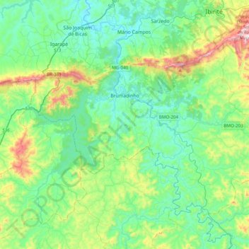
Nom : Carte topographique Brumadinho, altitude, relief.
Altitude moyenne : 889 m
Altitude minimum : 710 m
Altitude maximum : 1.478 m
Faire un don
Équipez-vous pour votre prochaine aventure :
En tant que Partenaire Amazon, ce site perçoit une commission sur les achats éligibles sans surcoût pour vous.
Autres cartes topographiques
Cliquez sur une carte pour visualiser sa topographie, son altitude et son relief.
Lagoa dos Ingleses
Brazil > Minas Gerais > Região Metropolitana de Belo Horizonte > Nova Lima
Altitude moyenne : 1.335 m
São Francisco de Assis
Brazil > Minas Gerais > Região Metropolitana de Belo Horizonte > Lagoa Santa
Altitude moyenne : 754 m
Belo Horizonte
Brazil > Minas Gerais > Região Metropolitana de Belo Horizonte
In 1893, due to the climatic and topographic conditions, Curral Del Rey was selected by Minas Gerais governor Afonso Pena among other cities as the location for the new economic and cultural center of the state, under the new name of Cidade de Minas, or City of Minas.
Altitude moyenne : 904 m
Itamarati
Brazil > Minas Gerais > Região Metropolitana de Belo Horizonte > Belo Horizonte
Altitude moyenne : 831 m
Faire un don
Équipez-vous pour votre prochaine aventure :
En tant que Partenaire Amazon, ce site perçoit une commission sur les achats éligibles sans surcoût pour vous.
Contagem
Brazil > Minas Gerais > Região Metropolitana de Belo Horizonte > Contagem
The city belongs to the metropolitan mesoregion and to the microregion of Belo Horizonte, has a territorial extension of 195.2 square kilometres (75.4 square miles), and borders the municipalities of Ribeirão das Neves, Esmeraldas, Betim, Ibirité and Belo Horizonte. The elevation of the city hall is 939…
Altitude moyenne : 890 m
Pampulha
Brazil > Minas Gerais > Região Metropolitana de Belo Horizonte > Belo Horizonte > Pampulha
Altitude moyenne : 826 m