
Carte topographique Trigg Beach
Cliquez sur la carte pour afficher l’altitude.
À propos de cette carte
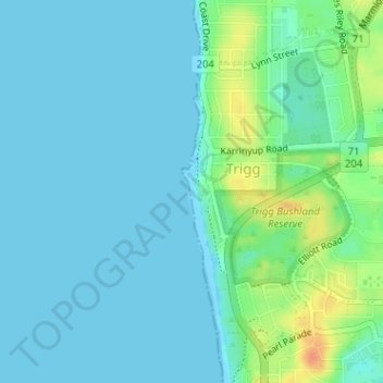
Nom : Carte topographique Trigg Beach, altitude, relief.
Altitude moyenne : 9 m
Altitude minimum : 0 m
Altitude maximum : 42 m
Autres cartes topographiques
Cliquez sur une carte pour visualiser sa topographie, son altitude et son relief.
Perth
Perth, the capital of Western Australia, is situated on the Swan Coastal Plain, a flat expanse of sandy soil nestled between the Indian Ocean to the west and the Darling Scarp to the east. The Darling Scarp, also known as the Darling Range, is a low escarpment that extends north–south, marking a distinct…
Altitude moyenne : 26 m
Mount Meharry
The summit of Mount Meharry can be reached from the Great Northern Highway via an unsealed road 16 kilometres (9.9 mi) in length and a vehicular track 21 kilometres (13 mi) in length. Permission should be sought from the managers of the land over which the road and track pass. These are Juna Downs Station and…
Altitude moyenne : 1.030 m