
Faire un don
Équipez-vous pour votre prochaine aventure :
En tant que Partenaire Amazon, ce site perçoit une commission sur les achats éligibles sans surcoût pour vous.
Carte topographique Placerville
Cliquez sur la carte pour afficher l’altitude.
Faire un don
Équipez-vous pour votre prochaine aventure :
En tant que Partenaire Amazon, ce site perçoit une commission sur les achats éligibles sans surcoût pour vous.
Placerville
The region east of Placerville, popularly known as Apple Hill and Pleasant Valley, is becoming a center for wine production. The wine region is officially designated as the El Dorado AVA. The largest wineries in the area are Boeger, Lava Cap and Madrona, but most of the 30 plus wineries surrounding Placerville are family owned and smaller in wine grape and wine production. The region is "renown for making vibrantly flavorful, distinctly delicious wines, grown in the dramatic elevations of the Sierra Nevada." The area is increasingly a center for sophisticated production of Rhone style wines, noted by El Dorado County having a local chapter of the Rhone Rangers winemaker association.
Faire un don
Équipez-vous pour votre prochaine aventure :
En tant que Partenaire Amazon, ce site perçoit une commission sur les achats éligibles sans surcoût pour vous.
À propos de cette carte
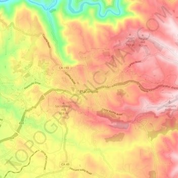
Nom : Carte topographique Placerville, altitude, relief.
Lieu : Placerville, El Dorado County, California, United States (38.71286 -120.85147 38.74854 -120.75050)
Altitude moyenne : 587 m
Altitude minimum : 265 m
Altitude maximum : 807 m
Faire un don
Équipez-vous pour votre prochaine aventure :
En tant que Partenaire Amazon, ce site perçoit une commission sur les achats éligibles sans surcoût pour vous.