
Carte topographique Mount Scott
Carte interactive
Cliquez sur la carte pour afficher l’altitude.
À propos de cette carte
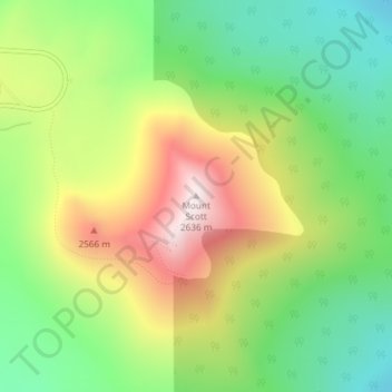
Nom : Carte topographique Mount Scott, altitude, relief.
Lieu : Mount Scott, Klamath County, Oregon, United States (42.92295 -122.01626 42.92305 -122.01616)
Altitude moyenne : 2.295 m
Altitude minimum : 2.004 m
Altitude maximum : 2.703 m
There is one trail to the summit of Mount Scott. Starting on Rim Drive, the trail is about 2.5 miles (4.0 km) long. It has many switchbacks, and ends at the fire lookout tower on the summit. The trailhead is at an elevation of 7,683 feet (2,342 m), and the trail climbs approximately 1,479 feet (451 m) to the top of Mount Scott at 8,934 feet (2,723 m).
Autres cartes topographiques
Cliquez sur une carte pour visualiser sa topographie, son altitude et son relief.
Klamath Falls
United States > Oregon > Klamath County
Klamath Falls, Klamath County, Oregon, 97601, United States
Altitude moyenne : 1.312 m
Dairy
United States > Oregon > Klamath County
Dairy, Klamath County, Oregon, 97625, United States
Altitude moyenne : 1.300 m
Crater Lake National Park
United States > Oregon > Klamath County
Crater Lake National Park, Klamath County, Oregon, 97604, United States
Altitude moyenne : 1.726 m
Rock Point
United States > Oregon > Klamath County
Rock Point, Klamath County, Oregon, 97731, United States
Altitude moyenne : 1.415 m
Altamont
United States > Oregon > Klamath County
Altamont, Klamath County, Oregon, 97603, United States
Altitude moyenne : 1.310 m
Lake of the Woods
United States > Oregon > Klamath County
Lake of the Woods, Klamath County, Oregon, United States
Altitude moyenne : 1.588 m
Chemult
United States > Oregon > Klamath County
Chemult, Klamath County, Oregon, United States
Altitude moyenne : 1.480 m
Crescent
United States > Oregon > Klamath County
Crescent, Klamath County, Oregon, United States
Altitude moyenne : 1.389 m
Sprague River
United States > Oregon > Klamath County
Sprague River, Klamath County, Oregon, 97639, United States
Altitude moyenne : 1.472 m
Malin
United States > Oregon > Klamath County
Malin, Klamath County, Oregon, United States
Altitude moyenne : 1.241 m
Altamont
United States > Oregon > Klamath County > Altamont
Altamont, Klamath County, Oregon, 97603, United States
Altitude moyenne : 1.285 m
Merrill
United States > Oregon > Klamath County
Merrill, Klamath County, Oregon, United States
Altitude moyenne : 1.241 m
Fort Klamath
United States > Oregon > Klamath County
Fort Klamath, Klamath County, Oregon, United States
Altitude moyenne : 1.273 m
Chiloquin
United States > Oregon > Klamath County
Chiloquin, Klamath County, Oregon, United States
Altitude moyenne : 1.302 m
Beatty
United States > Oregon > Klamath County
Beatty, Klamath County, Oregon, 97602, United States
Altitude moyenne : 1.330 m
Odell Lake
United States > Oregon > Klamath County > Odell Lake
Odell Lake, Klamath County, Oregon, United States
Altitude moyenne : 1.492 m
Crater Lake
United States > Oregon > Klamath County
Crater Lake, Klamath County, Oregon, United States
Altitude moyenne : 1.971 m
Bonanza
United States > Oregon > Klamath County
Bonanza, Klamath County, Oregon, United States
Altitude moyenne : 1.263 m
Keno
United States > Oregon > Klamath County
Keno, Klamath County, Oregon, 97627, United States
Altitude moyenne : 1.287 m
Mount Mazama
United States > Oregon > Klamath County
Mount Mazama, Klamath County, Oregon, United States
Altitude moyenne : 1.880 m