
Carte topographique Berkshire County
Carte interactive
Cliquez sur la carte pour afficher l’altitude.
À propos de cette carte
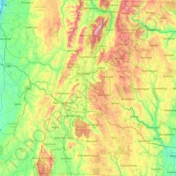
Nom : Carte topographique Berkshire County, altitude, relief.
Lieu : Berkshire County, Massachusetts, United States of America (42.03982 -73.50814 42.74585 -72.94944)
Altitude moyenne : 359 m
Altitude minimum : 2 m
Altitude maximum : 1.061 m
Running north-south through the county are the Hoosac Range of the Berkshire Hills in the eastern part of the county and the Taconic Mountains in the western part of the county. Due to their elevation, the Berkshires attract tourists and summer residents eager to escape the heat of the lowlands.